IMAGES TAKEN NEAR TO
Catton, HEXHAM, NE47 9QS
Introduction
This page details the photographs taken nearby to NE47 9QS by members of the Geograph project.
The Geograph project started in 2005 with the aim of publishing, organising and preserving representative images for every square kilometre of Great Britain, Ireland and the Isle of Man.

There are currently over 7.5m images from over14,400 individuals and you can help contribute to the project by visiting https://www.geograph.org.uk
Image Map
Images are licensed for reuse under creativecommons.org/licenses/by-sa/2.0
Notes
- Clicking on the map will re-center to the selected point.
- The higher the marker number, the further away the image location is from the centre of the postcode.
Image Listing (54 Images Found)
Images are licensed for reuse under creativecommons.org/licenses/by-sa/2.0
Image
Details
Distance
1
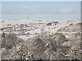
Catton in the snow
Photo taken from above the first bend in the minor road to Lonkley Head above Allendale Town in Image
Image: © Mike Quinn
Taken: 6 Jan 2010
0.02 miles
4
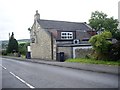
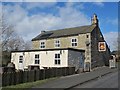
The Crown inn, Catton
At the north (top) end of the village; by the B6295.
Image: © Stanley Howe
Taken: 22 Aug 2013
0.03 miles
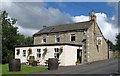
5
The Crown, Catton
Image: © Mike Quinn
Taken: 21 Mar 2014
0.03 miles
6
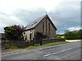
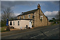
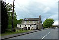
The Former St Paul's Church, Catton
This building is now a house.
Image: © Bill Henderson
Taken: 14 Jun 2013
0.04 miles
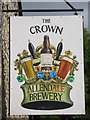
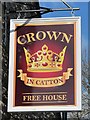
8
The Crown
Recently re-opened by the owners of the Allendale Brewery.
Image: © Mike Quinn
Taken: 4 Aug 2008
0.04 miles
10
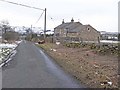
Lea Cottage
On the outskirts of Catton.
Image: © Oliver Dixon
Taken: 11 Feb 2010
0.05 miles