IMAGES TAKEN NEAR TO
Leadgate, HEXHAM, NE47 9PR
Introduction
This page details the photographs taken nearby to Leadgate, NE47 9PR by members of the Geograph project.
The Geograph project started in 2005 with the aim of publishing, organising and preserving representative images for every square kilometre of Great Britain, Ireland and the Isle of Man.

There are currently over 7.5m images from over14,400 individuals and you can help contribute to the project by visiting https://www.geograph.org.uk
Image Map
Images are licensed for reuse under creativecommons.org/licenses/by-sa/2.0
Notes
- Clicking on the map will re-center to the selected point.
- The higher the marker number, the further away the image location is from the centre of the postcode.
Image Listing (465 Images Found)
Images are licensed for reuse under creativecommons.org/licenses/by-sa/2.0
Image
Details
Distance
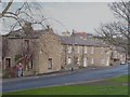
2
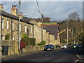
(Part of) Allendale Town (4)
Looking along the Hexham road (B6303) towards Image
Image: © Mike Quinn
Taken: 12 Nov 2013
0.01 miles
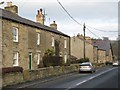
3

Wooden playground objects, Allendale School
Interesting wooden artifacts in the playground.
Image: © Oliver Dixon
Taken: 30 Dec 2008
0.02 miles
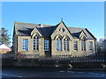
4

The former Allendale First School - northwest gable
Image: © Mike Quinn
Taken: 3 Dec 2019
0.02 miles
5
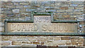
The former Allendale First School - date stone on northwest gable
See Image
Image: © Mike Quinn
Taken: 3 Dec 2019
0.02 miles