IMAGES TAKEN NEAR TO
Allendale, HEXHAM, NE47 9NX
Introduction
This page details the photographs taken nearby to NE47 9NX by members of the Geograph project.
The Geograph project started in 2005 with the aim of publishing, organising and preserving representative images for every square kilometre of Great Britain, Ireland and the Isle of Man.

There are currently over 7.5m images from over14,400 individuals and you can help contribute to the project by visiting https://www.geograph.org.uk
Image Map
Images are licensed for reuse under creativecommons.org/licenses/by-sa/2.0
Notes
- Clicking on the map will re-center to the selected point.
- The higher the marker number, the further away the image location is from the centre of the postcode.
Image Listing (26 Images Found)
Images are licensed for reuse under creativecommons.org/licenses/by-sa/2.0
Image
Details
Distance
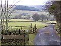
1
Keenleyside Hill
Fields above Keenleyside Hill Farm with Whitfield Moor in the background.
Image: © Peter McDermott
Taken: 22 Aug 2009
0.01 miles
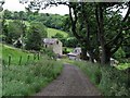
2
Keenleyside Hill Farm
In West Allendale.
Image: © Oliver Dixon
Taken: 20 Feb 2015
0.02 miles
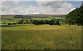
3
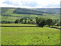
Pastures above Keenleyside Hill Farm
Across the valley of the West Allen in Image can be seen Greystone (almost hidden in trees), the A686 running left to right marked by a line of trees, and Parmontley Cottage nestled in the lower left corner of the large plantation in the middle distance. Whitfield Moor is in the far distance.
Image: © Mike Quinn
Taken: 29 Jun 2007
0.11 miles
4
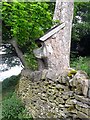
Owl nesting box?
Not quite sure what this object is on a tree near Gate House. A hole in sawn-off bough has been roofed over. Possibly an owl nesting box.
Image: © Oliver Dixon
Taken: 2 Jun 2010
0.13 miles
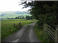
7
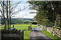
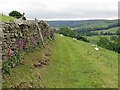
Access road for farm at Keenleyside Hill
Keenleyside Hill is a farm on the east side of West Allendale; its access road descends from a minor road at the edge of moorland at an altitude of over 350 metres.
Image: © Trevor Littlewood
Taken: 1 Oct 2020
0.15 miles
8
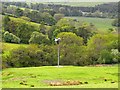
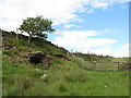
Wind turbine, West Allendale
One of a number of small privately-owned and operated wind turbines in the Allendale area. This one is close to Gate House.
Image: © Oliver Dixon
Taken: 2 Jun 2010
0.16 miles