IMAGES TAKEN NEAR TO
Allendale, HEXHAM, NE47 9NN
Introduction
This page details the photographs taken nearby to NE47 9NN by members of the Geograph project.
The Geograph project started in 2005 with the aim of publishing, organising and preserving representative images for every square kilometre of Great Britain, Ireland and the Isle of Man.

There are currently over 7.5m images from over14,400 individuals and you can help contribute to the project by visiting https://www.geograph.org.uk
Image Map
Images are licensed for reuse under creativecommons.org/licenses/by-sa/2.0
Notes
- Clicking on the map will re-center to the selected point.
- The higher the marker number, the further away the image location is from the centre of the postcode.
Image Listing (36 Images Found)
Images are licensed for reuse under creativecommons.org/licenses/by-sa/2.0
Image
Details
Distance
1
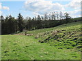
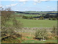
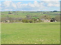
Rough pastures and plantation near Hill House
Image: © Mike Quinn
Taken: 16 Apr 2012
0.07 miles
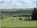
9
Stone stile in wall above Oakeydean Burn
Image: © Mike Quinn
Taken: 16 Apr 2012
0.15 miles
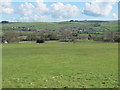
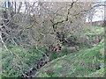
10
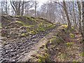
Footpath alongside the Oakeydean Burn
This muddy footpath follows the line of one of the inclined flues which carried the fumes from the Allen Lead Smelter up to the chimneys on Dryburn Moor (see Image).
Image: © Oliver Dixon
Taken: 7 Apr 2010
0.15 miles