IMAGES TAKEN NEAR TO
Thornley Gate, HEXHAM, NE47 9NG
Introduction
This page details the photographs taken nearby to NE47 9NG by members of the Geograph project.
The Geograph project started in 2005 with the aim of publishing, organising and preserving representative images for every square kilometre of Great Britain, Ireland and the Isle of Man.

There are currently over 7.5m images from over14,400 individuals and you can help contribute to the project by visiting https://www.geograph.org.uk
Image Map
Images are licensed for reuse under creativecommons.org/licenses/by-sa/2.0
Notes
- Clicking on the map will re-center to the selected point.
- The higher the marker number, the further away the image location is from the centre of the postcode.
Image Listing (223 Images Found)
Images are licensed for reuse under creativecommons.org/licenses/by-sa/2.0
Image
Details
Distance


9
Pastures and woodland above the River East Allen
Image: © Mike Quinn
Taken: 13 Dec 2007
0.10 miles
10
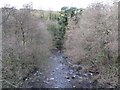
The East Allen at Bridge End - downstream
Image: © Mike Quinn
Taken: 23 Nov 2007
0.10 miles