IMAGES TAKEN NEAR TO
Catton, HEXHAM, NE47 9LN
Introduction
This page details the photographs taken nearby to NE47 9LN by members of the Geograph project.
The Geograph project started in 2005 with the aim of publishing, organising and preserving representative images for every square kilometre of Great Britain, Ireland and the Isle of Man.

There are currently over 7.5m images from over14,400 individuals and you can help contribute to the project by visiting https://www.geograph.org.uk
Image Map
Images are licensed for reuse under creativecommons.org/licenses/by-sa/2.0
Notes
- Clicking on the map will re-center to the selected point.
- The higher the marker number, the further away the image location is from the centre of the postcode.
Image Listing (31 Images Found)
Images are licensed for reuse under creativecommons.org/licenses/by-sa/2.0
Image
Details
Distance
1
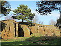
Disused quarry northeast of Old Town (2)
Image: © Mike Quinn
Taken: 30 Mar 2012
0.09 miles
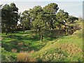

8
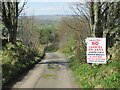
You've Been Warned
Could be argued that this is also unsuitable for walkers with arthritic knees. Definitely needed a coffee break at the bottom ---- luckily we brought our own.
Image: © Les Hull
Taken: 20 Apr 2022
0.13 miles
9
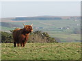
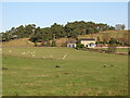
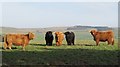
Rough pastures west of High Sunnyside
Appropriately, the farm buildings on the far side of the valley, just to the right of the bulls' head, are those at Bull's Hill Farm in NY8456; on the far horizon (centre) is Image
Image: © Mike Quinn
Taken: 30 Mar 2012
0.15 miles
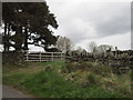
10
Rough pastures west of High Sunnyside (2)
Image: © Mike Quinn
Taken: 30 Mar 2012
0.16 miles