IMAGES TAKEN NEAR TO
Allenheads, HEXHAM, NE47 9JW
Introduction
This page details the photographs taken nearby to NE47 9JW by members of the Geograph project.
The Geograph project started in 2005 with the aim of publishing, organising and preserving representative images for every square kilometre of Great Britain, Ireland and the Isle of Man.

There are currently over 7.5m images from over14,400 individuals and you can help contribute to the project by visiting https://www.geograph.org.uk
Image Map
Images are licensed for reuse under creativecommons.org/licenses/by-sa/2.0
Notes
- Clicking on the map will re-center to the selected point.
- The higher the marker number, the further away the image location is from the centre of the postcode.
Image Listing (33 Images Found)
Images are licensed for reuse under creativecommons.org/licenses/by-sa/2.0
Image
Details
Distance
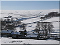
2
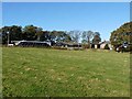
Line of trees at Hammershield Farm
Overlooking Allendale.
Image: © Oliver Dixon
Taken: 20 Oct 2010
0.04 miles
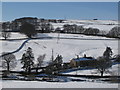
4
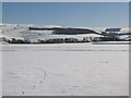
Snowy pastures near Hammer Shields (2)
Looking across East Allen Dale towards Byerhope. The buildings are (right to left) Image (photo by Les Hull), the Image (seen without the snow in Image), the Image and Image
Image: © Mike Quinn
Taken: 2 Mar 2010
0.13 miles
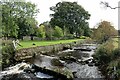
5

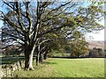
Hay meadow, Thorn Green
View over the dyke from the campsite.
Image: © Richard Webb
Taken: 30 Jun 2008
0.16 miles
7
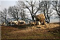
Ewes feeding
Ewes just about ready to lamb.
Image: © Helen Wilkinson
Taken: 20 Mar 2009
0.16 miles
10
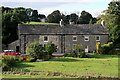
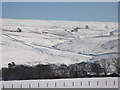
Burnfoot, Allenheads
Burnfoot Farmhouse and barn were built in the late 17th century. An inscription above a lintel reads: ANNO DOMINI 1678 with the initials 'W D'. The house was altered in the late 18th century and the barn added in the early 19th century.
Burnfoot is a Grade II Listed Building (1154819): https://historicengland.org.uk/listing/the-list/list-entry/1154819
The house on the hill behind is Hammershield Image
Image: © Andrew Curtis
Taken: 23 Sep 2022
0.19 miles