IMAGES TAKEN NEAR TO
Allenheads, HEXHAM, NE47 9JS
Introduction
This page details the photographs taken nearby to NE47 9JS by members of the Geograph project.
The Geograph project started in 2005 with the aim of publishing, organising and preserving representative images for every square kilometre of Great Britain, Ireland and the Isle of Man.

There are currently over 7.5m images from over14,400 individuals and you can help contribute to the project by visiting https://www.geograph.org.uk
Image Map
Images are licensed for reuse under creativecommons.org/licenses/by-sa/2.0
Notes
- Clicking on the map will re-center to the selected point.
- The higher the marker number, the further away the image location is from the centre of the postcode.
Image Listing (39 Images Found)
Images are licensed for reuse under creativecommons.org/licenses/by-sa/2.0
Image
Details
Distance
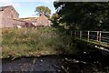
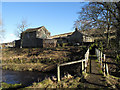
1
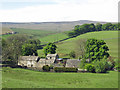
Peasmeadows Cottage from River East Allen
Image: © Andrew Curtis
Taken: 6 Oct 2020
0.01 miles
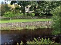
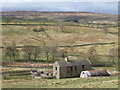
3
Peasmeadows
A similar view in the snow of March 2010 is shown in Image
Image: © Mike Quinn
Taken: 21 May 2018
0.03 miles
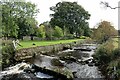
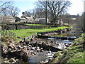
7
Peasmeadows
The collection of buildings that make up Peasmeadows is seen here over a footbridge across the River East Allen.
Image: © Trevor Littlewood
Taken: 10 Feb 2011
0.04 miles
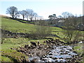
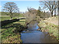
8
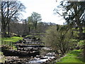
Mini-weirs on the River East Allen at Peasmeadows
Image: © Mike Quinn
Taken: 12 Apr 2009
0.04 miles