IMAGES TAKEN NEAR TO
Allenheads, HEXHAM, NE47 9JL
Introduction
This page details the photographs taken nearby to NE47 9JL by members of the Geograph project.
The Geograph project started in 2005 with the aim of publishing, organising and preserving representative images for every square kilometre of Great Britain, Ireland and the Isle of Man.

There are currently over 7.5m images from over14,400 individuals and you can help contribute to the project by visiting https://www.geograph.org.uk
Image Map
Images are licensed for reuse under creativecommons.org/licenses/by-sa/2.0
Notes
- Clicking on the map will re-center to the selected point.
- The higher the marker number, the further away the image location is from the centre of the postcode.
Image Listing (12 Images Found)
Images are licensed for reuse under creativecommons.org/licenses/by-sa/2.0
Image
Details
Distance
6
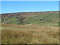
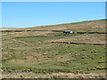
Swin Hope around Stripe House (3)
Stripe House is the nearer of the two buildings - see Image
Image: © Mike Quinn
Taken: 18 Apr 2014
0.19 miles
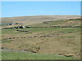
8
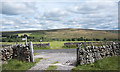
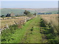
Meeting point of routes
Public footpaths approach the minor road between the gateways from four directions.
The obvious valley slot is East Allendale and the shallow upland dome beyond it is Green Hill.
Image: © Trevor Littlewood
Taken: 24 Jul 2020
0.20 miles
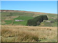
10
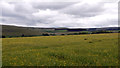
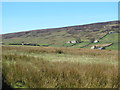
Hayfield, East Allendale
The field is rich in its variety of plants but with buttercups dominating in the wide view seen here. The valley of the River East Allen lies beyond the field.
Image: © Trevor Littlewood
Taken: 12 Jun 2012
0.24 miles