IMAGES TAKEN NEAR TO
Allenheads, HEXHAM, NE47 9HJ
Introduction
This page details the photographs taken nearby to NE47 9HJ by members of the Geograph project.
The Geograph project started in 2005 with the aim of publishing, organising and preserving representative images for every square kilometre of Great Britain, Ireland and the Isle of Man.

There are currently over 7.5m images from over14,400 individuals and you can help contribute to the project by visiting https://www.geograph.org.uk
Image Map
Images are licensed for reuse under creativecommons.org/licenses/by-sa/2.0
Notes
- Clicking on the map will re-center to the selected point.
- The higher the marker number, the further away the image location is from the centre of the postcode.
Image Listing (89 Images Found)
Images are licensed for reuse under creativecommons.org/licenses/by-sa/2.0
Image
Details
Distance
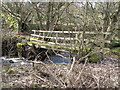
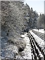
3
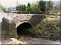
Footpath and leat below School Plantation
The leat presumably once served to supply water for the extensive mining industry in Allendale.
Image: © Oliver Dixon
Taken: 25 Feb 2013
0.08 miles
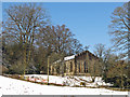
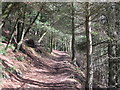
4
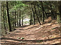
Footpath through the pines (2)
Looking down towards the Dirt Pot road.
Image: © Mike Quinn
Taken: 9 Mar 2008
0.08 miles
6
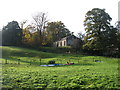
Former church in Allenheads
This former church is now a Grade 2 listed private house. I have been unable to find out to which saint the church was dedicated.
Image: © David Purchase
Taken: 15 Oct 2016
0.09 miles
7
Former church, Allenheads
The building, which replaced an earlier church of 1701, was built in the mid-1820s and was the family chapel of the Beaumonts, Northumberland landowners. The Beaumont-Blackett family owned one of the two main mining companies that operated in Weardale, Alston Moor and Allendale (the other was the London Lead Company) http://www.durhamintime.org.uk/durham_miner/weardale_lead_mining.pdf . It is now a private house.
The building is Grade II listed https://www.historicengland.org.uk/listing/the-list/list-entry/1042964 .
Image: © Mike Quinn
Taken: 5 Apr 2018
0.10 miles
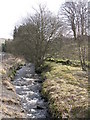
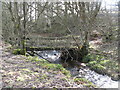
9
The infant River East Allen
Just to the northeast of the centre of Allenheads.
Image: © Mike Quinn
Taken: 5 Apr 2018
0.11 miles
10
Footpath through the pines
The path leads up from the Dirt Pot road to the B6295.
Image: © Mike Quinn
Taken: 9 Mar 2008
0.11 miles