IMAGES TAKEN NEAR TO
Allenheads, HEXHAM, NE47 9HD
Introduction
This page details the photographs taken nearby to NE47 9HD by members of the Geograph project.
The Geograph project started in 2005 with the aim of publishing, organising and preserving representative images for every square kilometre of Great Britain, Ireland and the Isle of Man.

There are currently over 7.5m images from over14,400 individuals and you can help contribute to the project by visiting https://www.geograph.org.uk
Image Map
Images are licensed for reuse under creativecommons.org/licenses/by-sa/2.0
Notes
- Clicking on the map will re-center to the selected point.
- The higher the marker number, the further away the image location is from the centre of the postcode.
Image Listing (144 Images Found)
Images are licensed for reuse under creativecommons.org/licenses/by-sa/2.0
Image
Details
Distance
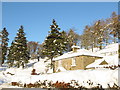
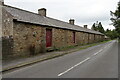
1
Former mine buildings in Allenheads
The other side of the buildings is shown in Image
Image: © Mike Quinn
Taken: 31 Aug 2018
0.01 miles
2
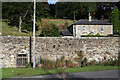
Fawside Level, Allenheads
The Fawside Level is an adit portal to the Beaumont Lead Mine dating to the mid-C19. Narrow horseshoe-arched portal with dressed stone surround in wall of squared rubble. Later concrete infill in head of arch protected with an iron gate. Above portal sunk rectangular panel with hollow-chamfered surround, plain. Work on this level commenced in 1776 but the similarity of the portal form to that of Blackett Level (1855) suggests the entrance was reconstructed in mid-C19.
The Fawside Level portal is Grade II Listed (1370612): https://historicengland.org.uk/listing/the-list/list-entry/1370612
Image: © Andrew Curtis
Taken: 8 Oct 2022
0.01 miles
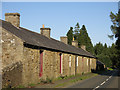
4
Roadside elevation of Beaumont Mine workshops, Allenheads
The other side of this building is shown here Image
Image: © Andrew Curtis
Taken: 23 Sep 2022
0.01 miles
5
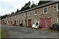
Beaumont Mine workshops, Allenheads
Former lead mine workshops. Mid C19. Rubble with slate roof. 2 storeys, 20 bays. 4 boarded doors with overlights, 2 cart entrances; 12-pane sash windows, some altered. 4 ridge and 2 end stone stacks. To left single storey 10-bay section with similar openings. One ground-floor room of the 2-storey section contains a hydraulic engine built by Armstrongs of Newcastle in 1847, used for pumping in the mine workings, and later to operate the estate sawmill.
Grade II Listed Buildings (1042967): https://historicengland.org.uk/listing/the-list/list-entry/1042967
Image: © Andrew Curtis
Taken: 23 Sep 2022
0.02 miles
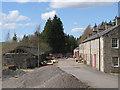
6
Former mine buildings in Allenheads
See also Image
Image: © Mike Quinn
Taken: 31 Aug 2018
0.02 miles
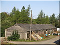
8
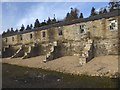
Allenheads Washing Floors
A relic from the days when lead mining was a major industry in Allenheads. Here the waste materials was separated from the lead ore.
Image: © Oliver Dixon
Taken: 22 Feb 2019
0.02 miles
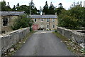
9
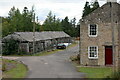
Former buildings of Beaumont Lead Mine, Allenheads
Image: © Andrew Curtis
Taken: 23 Sep 2022
0.02 miles