IMAGES TAKEN NEAR TO
Dale Park, HEXHAM, NE47 9HA
Introduction
This page details the photographs taken nearby to Dale Park, NE47 9HA by members of the Geograph project.
The Geograph project started in 2005 with the aim of publishing, organising and preserving representative images for every square kilometre of Great Britain, Ireland and the Isle of Man.

There are currently over 7.5m images from over14,400 individuals and you can help contribute to the project by visiting https://www.geograph.org.uk
Image Map
Images are licensed for reuse under creativecommons.org/licenses/by-sa/2.0
Notes
- Clicking on the map will re-center to the selected point.
- The higher the marker number, the further away the image location is from the centre of the postcode.
Image Listing (455 Images Found)
Images are licensed for reuse under creativecommons.org/licenses/by-sa/2.0
Image
Details
Distance
2
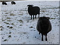
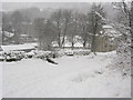
Hebridean sheep in the snow
The one at the front stamped its foot at me several times; fortunately, there was a field gate between us.
Image: © Mike Quinn
Taken: 6 Jan 2009
0.04 miles
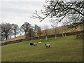
6
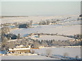
Panorama of snowy East Allen Dale (4 - Lonkley Head and The Hope)
Image: © Mike Quinn
Taken: 8 Jan 2010
0.06 miles
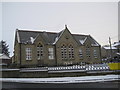
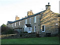
10

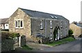
The former Allendale First School - southeast side
Image: © Mike Quinn
Taken: 3 Dec 2019
0.08 miles