IMAGES TAKEN NEAR TO
Allendale, HEXHAM, NE47 9ES
Introduction
This page details the photographs taken nearby to NE47 9ES by members of the Geograph project.
The Geograph project started in 2005 with the aim of publishing, organising and preserving representative images for every square kilometre of Great Britain, Ireland and the Isle of Man.

There are currently over 7.5m images from over14,400 individuals and you can help contribute to the project by visiting https://www.geograph.org.uk
Image Map
Images are licensed for reuse under creativecommons.org/licenses/by-sa/2.0
Notes
- Clicking on the map will re-center to the selected point.
- The higher the marker number, the further away the image location is from the centre of the postcode.
Image Listing (17 Images Found)
Images are licensed for reuse under creativecommons.org/licenses/by-sa/2.0
Image
Details
Distance
1
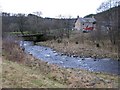
The valley of the River West Allen at Wide Eals
Image: © Mike Quinn
Taken: 27 Nov 2007
0.01 miles
2
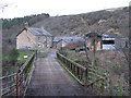
Wide Eals Farm and the bridge over the River West Allen
Image: © Mike Quinn
Taken: 27 Nov 2007
0.02 miles
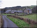
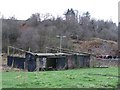
4
Wide Eals Farm
Wide Eals, a 19th. century Farm in the valley of the East Allen near the confluence of the East and West Allen.
Image: © Bill Cresswell
Taken: 12 Nov 2006
0.04 miles
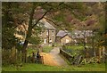
5
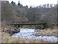
The bridge over the River West Allen at Wide Eals
Image: © Mike Quinn
Taken: 27 Nov 2007
0.04 miles
7
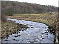
The River West Allen upstream of the bridge at Wide Eals
Image: © Mike Quinn
Taken: 27 Nov 2007
0.06 miles
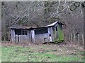
9
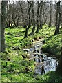
Overflow of River Allen
Small tributary from River Allen running through Wide Eals Farm
Image: © Christine Westerback
Taken: 7 Apr 2007
0.08 miles
10
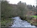
The River West Allen downstream of the bridge at Wide Eals
Image: © Mike Quinn
Taken: 27 Nov 2007
0.08 miles