IMAGES TAKEN NEAR TO
Allendale, HEXHAM, NE47 9DG
Introduction
This page details the photographs taken nearby to NE47 9DG by members of the Geograph project.
The Geograph project started in 2005 with the aim of publishing, organising and preserving representative images for every square kilometre of Great Britain, Ireland and the Isle of Man.

There are currently over 7.5m images from over14,400 individuals and you can help contribute to the project by visiting https://www.geograph.org.uk
Image Map
Images are licensed for reuse under creativecommons.org/licenses/by-sa/2.0
Notes
- Clicking on the map will re-center to the selected point.
- The higher the marker number, the further away the image location is from the centre of the postcode.
Image Listing (131 Images Found)
Images are licensed for reuse under creativecommons.org/licenses/by-sa/2.0
Image
Details
Distance
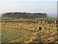
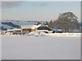
1
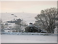
Snowy pastures near High Scotch Hall
Looking WSW across East Allen Dale towards Image on the horizon.
Image: © Mike Quinn
Taken: 3 Jan 2010
0.01 miles
2
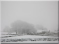
Snowy pastures and woodland near Scotch Halls
Image: © Mike Quinn
Taken: 27 Feb 2010
0.04 miles
5
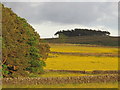
Buttercup meadows northwest of Green Hill
See Image
Image: © Mike Quinn
Taken: 16 Jun 2013
0.06 miles
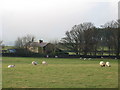
7
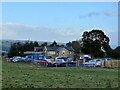
High Scotch Hall
It looks like a car dealer lives here.
Image: © Jay Pea
Taken: 25 Sep 2023
0.08 miles

9
Pastures near High Scotch Hall (2)
Looking across the valley of the River East Allen; the Image can just be seen on the horizon (centre).
Image: © Mike Quinn
Taken: 4 Jan 2008
0.09 miles
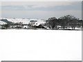
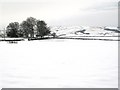
10
Snowy pastures near High Scotch Hall (2)
Image: © Mike Quinn
Taken: 3 Jan 2010
0.09 miles