IMAGES TAKEN NEAR TO
Forstersteads, HEXHAM, NE47 9AS
Introduction
This page details the photographs taken nearby to Forstersteads, NE47 9AS by members of the Geograph project.
The Geograph project started in 2005 with the aim of publishing, organising and preserving representative images for every square kilometre of Great Britain, Ireland and the Isle of Man.

There are currently over 7.5m images from over14,400 individuals and you can help contribute to the project by visiting https://www.geograph.org.uk
Image Map
Images are licensed for reuse under creativecommons.org/licenses/by-sa/2.0
Notes
- Clicking on the map will re-center to the selected point.
- The higher the marker number, the further away the image location is from the centre of the postcode.
Image Listing (101 Images Found)
Images are licensed for reuse under creativecommons.org/licenses/by-sa/2.0
Image
Details
Distance
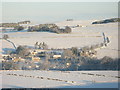
4
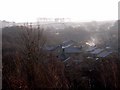
Panorama of snowy East Allen Dale (2 - The valley of Shield Burn and Leadgate Bank)
Image: © Mike Quinn
Taken: 8 Jan 2010
0.10 miles
5
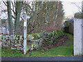
Footpath near Forstersteads
The footpath comes out on the B6303 on the bend approaching Allendale Town at around NY841562.
Image: © Mike Quinn
Taken: 5 Dec 2007
0.10 miles
6
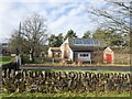
Fire station in Allendale Town
The fire station is in a quiet corner of the village on the north side of Shilburn Road.
Image: © Trevor Littlewood
Taken: 3 Feb 2017
0.10 miles
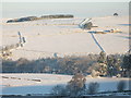
8
Panorama of snowy East Allen Dale (3 - The Dene and High Hope)
Image: © Mike Quinn
Taken: 8 Jan 2010
0.12 miles
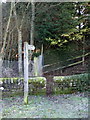
9
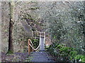
Footbridge over Shield Burn
Taken from the top of the steps down to the burn on the west side. For a view from stream level see Image
Image: © Mike Quinn
Taken: 5 Dec 2007
0.12 miles
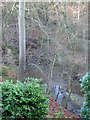
10
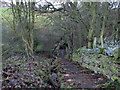
Steps on the footpath down to Shield Burn
Image: © Mike Quinn
Taken: 5 Dec 2007
0.12 miles