IMAGES TAKEN NEAR TO
Whitfield, HEXHAM, NE47 8LA
Introduction
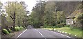
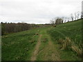
This page details the photographs taken nearby to NE47 8LA by members of the Geograph project.
The Geograph project started in 2005 with the aim of publishing, organising and preserving representative images for every square kilometre of Great Britain, Ireland and the Isle of Man.

There are currently over 7.5m images from over14,400 individuals and you can help contribute to the project by visiting https://www.geograph.org.uk
Image Map
Images are licensed for reuse under creativecommons.org/licenses/by-sa/2.0
Notes
- Clicking on the map will re-center to the selected point.
- The higher the marker number, the further away the image location is from the centre of the postcode.
Image Listing (6 Images Found)
Images are licensed for reuse under creativecommons.org/licenses/by-sa/2.0
Image
Details
Distance
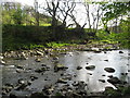
1
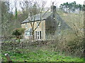
Burnmouth
Taken from near the gate on the right of way.
Image: © 27th Newcastle Scouts
Taken: 9 Apr 2007
0.01 miles

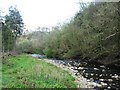
6
(Alleged) ford over the West Allen
Not passable on foot in late April 2007 (in boots - possibly in wellies).
Image: © Mike Quinn
Taken: 25 Apr 2007
0.20 miles