IMAGES TAKEN NEAR TO
Whitfield, HEXHAM, NE47 8JU
Introduction
This page details the photographs taken nearby to NE47 8JU by members of the Geograph project.
The Geograph project started in 2005 with the aim of publishing, organising and preserving representative images for every square kilometre of Great Britain, Ireland and the Isle of Man.

There are currently over 7.5m images from over14,400 individuals and you can help contribute to the project by visiting https://www.geograph.org.uk
Image Map
Images are licensed for reuse under creativecommons.org/licenses/by-sa/2.0
Notes
- Clicking on the map will re-center to the selected point.
- The higher the marker number, the further away the image location is from the centre of the postcode.
Image Listing (10 Images Found)
Images are licensed for reuse under creativecommons.org/licenses/by-sa/2.0
Image
Details
Distance


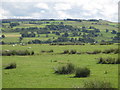
8
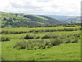
Pastures east of Rowside
Looking south down the valley of the River West Allen.
Image: © Mike Quinn
Taken: 18 Aug 2010
0.20 miles
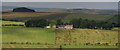
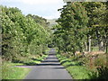
9
Road above Row Side
A minor road cul de sac which serves a few farms. It continues as a public byway down into the floor of West Allendale.
Image: © Oliver Dixon
Taken: 15 Jun 2013
0.23 miles