IMAGES TAKEN NEAR TO
Whitfield, HEXHAM, NE47 8JS
Introduction
This page details the photographs taken nearby to NE47 8JS by members of the Geograph project.
The Geograph project started in 2005 with the aim of publishing, organising and preserving representative images for every square kilometre of Great Britain, Ireland and the Isle of Man.

There are currently over 7.5m images from over14,400 individuals and you can help contribute to the project by visiting https://www.geograph.org.uk
Image Map
Images are licensed for reuse under creativecommons.org/licenses/by-sa/2.0
Notes
- Clicking on the map will re-center to the selected point.
- The higher the marker number, the further away the image location is from the centre of the postcode.
Image Listing (4 Images Found)
Images are licensed for reuse under creativecommons.org/licenses/by-sa/2.0
Image
Details
Distance
1
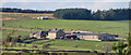
Huntershield Farm
View of Huntershield Farm seen from Staward.
Image: © Peter McDermott
Taken: 30 Oct 2010
0.02 miles
4
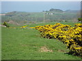
Burn near Huntershield Farm
The gorse marks the line of the (un-named) burn; Haining Hall in Image is on the right (first) horizon.
Image: © Mike Quinn
Taken: 2 May 2007
0.20 miles