IMAGES TAKEN NEAR TO
Ninebanks, HEXHAM, NE47 8DR
Introduction
This page details the photographs taken nearby to NE47 8DR by members of the Geograph project.
The Geograph project started in 2005 with the aim of publishing, organising and preserving representative images for every square kilometre of Great Britain, Ireland and the Isle of Man.

There are currently over 7.5m images from over14,400 individuals and you can help contribute to the project by visiting https://www.geograph.org.uk
Image Map
Images are licensed for reuse under creativecommons.org/licenses/by-sa/2.0
Notes
- Clicking on the map will re-center to the selected point.
- The higher the marker number, the further away the image location is from the centre of the postcode.
Image Listing (18 Images Found)
Images are licensed for reuse under creativecommons.org/licenses/by-sa/2.0
Image
Details
Distance
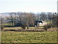
1
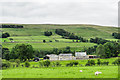
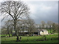
Dale House Farm
The farm is in West Allendale above the west side of the River West Allen.
Brownley Hill rises beyond the farm to the river's east.
Image: © Trevor Littlewood
Taken: 30 Aug 2020
0.00 miles
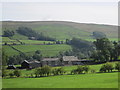
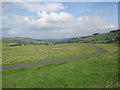
3
View across West Allendale
Compare with Image taken from an almost identical viewpoint. Dale House Farm in the middle distance with Ouston Fell on the horizon.
Image: © Oliver Dixon
Taken: 20 Feb 2015
0.01 miles
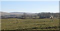
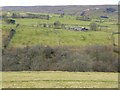
6
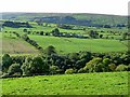
View across West Allendale
The farm in the middle distance is Dale House. The valley of the Mohope Burn lies beyond with Ouston Fell on the horizon.
Image: © Oliver Dixon
Taken: 30 Sep 2010
0.08 miles