IMAGES TAKEN NEAR TO
Ninebanks, HEXHAM, NE47 8DP
Introduction
This page details the photographs taken nearby to NE47 8DP by members of the Geograph project.
The Geograph project started in 2005 with the aim of publishing, organising and preserving representative images for every square kilometre of Great Britain, Ireland and the Isle of Man.

There are currently over 7.5m images from over14,400 individuals and you can help contribute to the project by visiting https://www.geograph.org.uk
Image Map
Images are licensed for reuse under creativecommons.org/licenses/by-sa/2.0
Notes
- Clicking on the map will re-center to the selected point.
- The higher the marker number, the further away the image location is from the centre of the postcode.
Image Listing (12 Images Found)
Images are licensed for reuse under creativecommons.org/licenses/by-sa/2.0
Image
Details
Distance
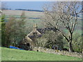
2
View from Middleside across the River West Allen Valley
What a great view. The owner told me he was snowed in for 32 days in December 2009 and January 2010. His wife went to work and couldn't get back.
Image: © Les Hull
Taken: 8 Sep 2010
0.10 miles
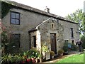
8
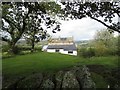
Solar Panels on House and Outbuildings near Middle
Image: © Les Hull
Taken: 26 Aug 2018
0.18 miles
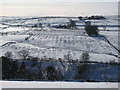
9
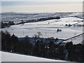
Snowy West Allen Dale near Nether Harsley
Image: © Mike Quinn
Taken: 2 Mar 2010
0.21 miles