IMAGES TAKEN NEAR TO
Bardon Mill, HEXHAM, NE47 7JS
Introduction
This page details the photographs taken nearby to NE47 7JS by members of the Geograph project.
The Geograph project started in 2005 with the aim of publishing, organising and preserving representative images for every square kilometre of Great Britain, Ireland and the Isle of Man.

There are currently over 7.5m images from over14,400 individuals and you can help contribute to the project by visiting https://www.geograph.org.uk
Image Map
Images are licensed for reuse under creativecommons.org/licenses/by-sa/2.0
Notes
- Clicking on the map will re-center to the selected point.
- The higher the marker number, the further away the image location is from the centre of the postcode.
Image Listing (8 Images Found)
Images are licensed for reuse under creativecommons.org/licenses/by-sa/2.0
Image
Details
Distance
1
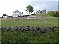
Parkhead
In a commanding position on the northern slopes above Tynedale.
Image: © Oliver Dixon
Taken: 15 Jun 2013
0.01 miles
2
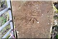
Ordnance Survey Cut Mark
This OS cut mark can be found on a gatepost SW side of Park Lane. It marks a point 155.293m above mean sea level.
Image: © Adrian Dust
Taken: 8 Feb 2020
0.16 miles
3
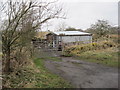
Corrugated Building near Vindolanda
Difficult to tell what may happen here. I assume it belongs to a local farmer.
Image: © Les Hull
Taken: 24 Mar 2010
0.19 miles
5
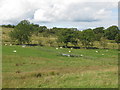
Pastures and woodland southwest of Layside
Image: © Mike Quinn
Taken: 26 Aug 2010
0.23 miles
6
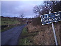
Byway open to all traffic
Leads to Vindolanda, Roman Fort. The sign may say unsuitable for motors but all vehicles are legally allowed to use it.
Image: © Tim
Taken: 21 Dec 2005
0.23 miles
7
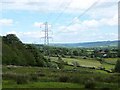
Pylons near Huntercrook
Along the northern slopes above Tynedale.
Image: © Oliver Dixon
Taken: 15 Jun 2013
0.24 miles
8
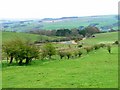
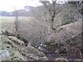
Bend, Park Lane
Taken on the Public Footpath from just east of Layside before dropping into Bean Burn.
Image: © Mick Garratt
Taken: 30 Apr 2006
0.24 miles