IMAGES TAKEN NEAR TO
Bardon Mill, HEXHAM, NE47 7JL
Introduction
This page details the photographs taken nearby to NE47 7JL by members of the Geograph project.
The Geograph project started in 2005 with the aim of publishing, organising and preserving representative images for every square kilometre of Great Britain, Ireland and the Isle of Man.

There are currently over 7.5m images from over14,400 individuals and you can help contribute to the project by visiting https://www.geograph.org.uk
Image Map
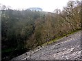
Images are licensed for reuse under creativecommons.org/licenses/by-sa/2.0
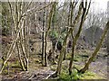
Notes
- Clicking on the map will re-center to the selected point.
- The higher the marker number, the further away the image location is from the centre of the postcode.
Image Listing (20 Images Found)
Images are licensed for reuse under creativecommons.org/licenses/by-sa/2.0
Image
Details
Distance
1
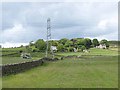
Birkshaw
Small cluster of houses on the northern slopes of Tynedale, seen from Westwood Cottages. Pylon and electricity transmission line in the foreground.
Image: © Oliver Dixon
Taken: 15 Jun 2013
0.03 miles
2
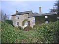
Birkshaw Farmhouse
Now houses Unique in Glass which is part of the Northumberland Art Tour.
http://www.uniqueinglass.com/index.php
Image: © Les Hull
Taken: 9 Dec 2009
0.05 miles
4
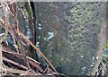
Ordnance Survey Cut Mark
This OS cut mark can be found on a gatepost west side of the road. It marks a point 153.232m above mean sea level.
Image: © Adrian Dust
Taken: 8 Feb 2020
0.13 miles
5

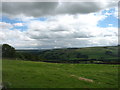
Field north-west of Birkshaw
The mound in the next door field at the end of the ridge is the remains of a Roman Signal Station excavated in 1991 and found to be heavily damaged by ploughing. It is close to the edge of the valley of the Chainley Burn and clearly visible from Vindolanda Roman Fort Image
Image: © Andrew Curtis
Taken: 24 Mar 2012
0.14 miles
6
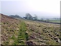
Track south of Barcombe South Quarry
High Birkshaw House can be seen ahead, on the minor road to Bardon Mill.
Image: © Andrew Curtis
Taken: 24 Mar 2012
0.16 miles
7

Colliery landslip, Westwood north of Bardon Mill
The OS map indicates historical drift mining in the area. The grey material is coal dust which suggests some kind of slippage of colliery waste. Whatever its origin it obstructs the course of a public footpath and could be quite hazardous given the unstable nature of the ground and the steep drop (right) to Chainley Burn.
Image: © David Kemp
Taken: 24 Sep 2018
0.19 miles
8
Landslip on east side of Chainley Burn
A large landslide of former colliery waste has occurred here leaving the narrow (lower) footpath feeling rather exposed. The trees on the distant hilltop are east of Park Head.
Image: © Andrew Curtis
Taken: 24 Mar 2012
0.19 miles
9
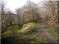
Junction of paths above Chainley Burn
The branch to the left descends to cross Chainley Burn at a footbridge near Low Fogrigg. The site of Henshaw Colliery was just south of there on the west side of the burn. The old waggonway along the east side of the valley continues past the site of Barcombe Colliery, below Birkshaw.
Image: © Andrew Curtis
Taken: 24 Mar 2012
0.20 miles
10
Ruined buildings, Barcombe Colliery, Birkshaw
This is the later site of Barcombe Colliery, just below Birkshaw, where it moved in the late C19th from it former site below Barcombe Hill Image
Barcombe Colliery operated from around 1850 to 1954 http://www.dmm.org.uk/colliery/b072.htm
Image: © Andrew Curtis
Taken: 24 Mar 2012
0.20 miles