IMAGES TAKEN NEAR TO
Bardon Mill, HEXHAM, NE47 7HB
Introduction
This page details the photographs taken nearby to NE47 7HB by members of the Geograph project.
The Geograph project started in 2005 with the aim of publishing, organising and preserving representative images for every square kilometre of Great Britain, Ireland and the Isle of Man.

There are currently over 7.5m images from over14,400 individuals and you can help contribute to the project by visiting https://www.geograph.org.uk
Image Map
Images are licensed for reuse under creativecommons.org/licenses/by-sa/2.0
Notes
- Clicking on the map will re-center to the selected point.
- The higher the marker number, the further away the image location is from the centre of the postcode.
Image Listing (6 Images Found)
Images are licensed for reuse under creativecommons.org/licenses/by-sa/2.0
Image
Details
Distance
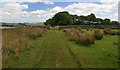
3
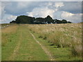
Track and rough pasture west of Cranberry Brow
Image: © Mike Quinn
Taken: 26 Aug 2010
0.06 miles
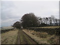
5
Cranberry Brow
View looking along the public Right of Way towards Cranberry Brow Farm (behind the plantation).
Image: © Peter McDermott
Taken: 8 Aug 2009
0.08 miles
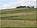
6
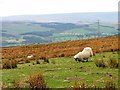
Rough Pasture, Cranberry Brow
I am not sure if this sheep was injured or a peculiarity of the breed to feed on its knees. It was one of several feeding this way.
Image: © Mick Garratt
Taken: 30 Apr 2006
0.15 miles