IMAGES TAKEN NEAR TO
Bardon Mill, HEXHAM, NE47 7EY
Introduction
This page details the photographs taken nearby to NE47 7EY by members of the Geograph project.
The Geograph project started in 2005 with the aim of publishing, organising and preserving representative images for every square kilometre of Great Britain, Ireland and the Isle of Man.

There are currently over 7.5m images from over14,400 individuals and you can help contribute to the project by visiting https://www.geograph.org.uk
Image Map
Images are licensed for reuse under creativecommons.org/licenses/by-sa/2.0
Notes
- Clicking on the map will re-center to the selected point.
- The higher the marker number, the further away the image location is from the centre of the postcode.
Image Listing (22 Images Found)
Images are licensed for reuse under creativecommons.org/licenses/by-sa/2.0
Image
Details
Distance
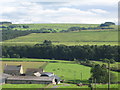
1
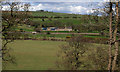
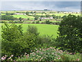
The valley of the River South Tyne between Shankfoot and Woodhall
Image: © Mike Quinn
Taken: 12 Aug 2010
0.00 miles
2
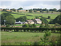
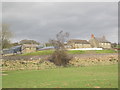
Woodhall
View from The Shank looking across the South Tyne to Woodhall Farm.
Image: © Peter McDermott
Taken: 12 Apr 2009
0.01 miles
5
The valley of the River South Tyne between Shankfoot and Woodhall (2)
Image: © Mike Quinn
Taken: 12 Aug 2010
0.02 miles
6
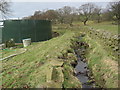
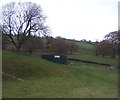
Man Made Water Course at Woodhall Farm
I think this was constructed to divert the Carrsgate Burn. Can't figure out why!
Image: © Les Hull
Taken: 24 Mar 2010
0.02 miles
8
Woodhall
Looking across the valley of the River South Tyne towards farmland west of Haughstrother Wood.
Image: © Mike Quinn
Taken: 26 Aug 2010
0.04 miles
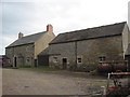
9
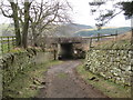
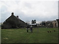
Railway Underpass and Footpath at Woodhall Farm
Image: © Les Hull
Taken: 24 Mar 2010
0.04 miles