IMAGES TAKEN NEAR TO
Bardon Mill, HEXHAM, NE47 7DW
Introduction
This page details the photographs taken nearby to NE47 7DW by members of the Geograph project.
The Geograph project started in 2005 with the aim of publishing, organising and preserving representative images for every square kilometre of Great Britain, Ireland and the Isle of Man.

There are currently over 7.5m images from over14,400 individuals and you can help contribute to the project by visiting https://www.geograph.org.uk
Image Map
Images are licensed for reuse under creativecommons.org/licenses/by-sa/2.0
Notes
- Clicking on the map will re-center to the selected point.
- The higher the marker number, the further away the image location is from the centre of the postcode.
Image Listing (10 Images Found)
Images are licensed for reuse under creativecommons.org/licenses/by-sa/2.0
Image
Details
Distance
4
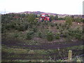
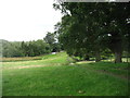
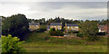
Geoff's Christmas Tree Farm.
Good bit of agricultural diversification. The farmer who grows these trees also runs a cattery, does groundwork, leases out land for advertising hoardings as well as running sheep
Image: © Tim
Taken: 21 Dec 2005
0.12 miles
6
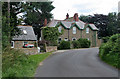
Cragside
Cragside House above Bardon Mill.
Image: © Peter McDermott
Taken: 8 Aug 2009
0.18 miles
7
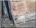
Ordnance Survey Cut Mark
This OS cut mark can be found on The Poplars. It marks a point 101.492m above mean sea level.
Image: © Adrian Dust
Taken: 8 Feb 2020
0.21 miles
10
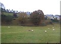
Houses on Millfield Court, Bardon Mill
Image: © Robin Webster
Taken: 14 Sep 2019
0.24 miles