IMAGES TAKEN NEAR TO
Bardon Mill, HEXHAM, NE47 7DE
Introduction
This page details the photographs taken nearby to NE47 7DE by members of the Geograph project.
The Geograph project started in 2005 with the aim of publishing, organising and preserving representative images for every square kilometre of Great Britain, Ireland and the Isle of Man.

There are currently over 7.5m images from over14,400 individuals and you can help contribute to the project by visiting https://www.geograph.org.uk
Image Map
Images are licensed for reuse under creativecommons.org/licenses/by-sa/2.0
Notes
- Clicking on the map will re-center to the selected point.
- The higher the marker number, the further away the image location is from the centre of the postcode.
Image Listing (25 Images Found)
Images are licensed for reuse under creativecommons.org/licenses/by-sa/2.0
Image
Details
Distance
1
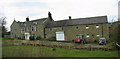
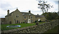
Allensgreen Cottages
Some of the houses at Allensgreen.
Image: © Jay Pea
Taken: 30 Sep 2023
0.01 miles
2
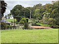
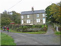
Wooded hamlet
The road and cottages are surrounded by trees at Allensgreen.
Image: © Jay Pea
Taken: 30 Sep 2023
0.02 miles
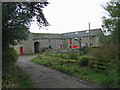
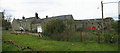
4
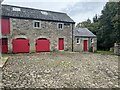
Allensgreen Barn
A recent conversion into three houses possibly for self catering.
Image: © Les Hull
Taken: 29 Oct 2008
0.03 miles
5
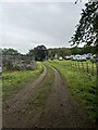
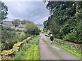
Farm track
The footpath follows the farm track in front of Allengreen.
Image: © Jay Pea
Taken: 30 Sep 2023
0.06 miles
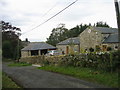
7
Farm buildings
Traditional farm barns at Allengreen.
Image: © Jay Pea
Taken: 30 Sep 2023
0.07 miles