IMAGES TAKEN NEAR TO
Bardon Mill, HEXHAM, NE47 7BN
Introduction
This page details the photographs taken nearby to NE47 7BN by members of the Geograph project.
The Geograph project started in 2005 with the aim of publishing, organising and preserving representative images for every square kilometre of Great Britain, Ireland and the Isle of Man.

There are currently over 7.5m images from over14,400 individuals and you can help contribute to the project by visiting https://www.geograph.org.uk
Image Map
Images are licensed for reuse under creativecommons.org/licenses/by-sa/2.0
Notes
- Clicking on the map will re-center to the selected point.
- The higher the marker number, the further away the image location is from the centre of the postcode.
Image Listing (18 Images Found)
Images are licensed for reuse under creativecommons.org/licenses/by-sa/2.0
Image
Details
Distance
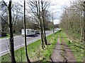
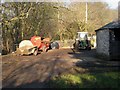
3
A69 at Whitechapel Farm
The busy Carlisle to Newcastle A69 trunk road crosses the Whitechapel Burn at this point. Fortunately there is room in the verge to allow walkers to get from one footpath joining the road to another.
Image: © Oliver Dixon
Taken: 19 Dec 2007
0.05 miles
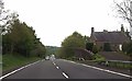
4
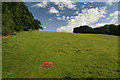
Whitechapel
Fields near Whitechapel Farm.
Image: © Peter McDermott
Taken: 8 Aug 2009
0.06 miles
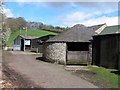
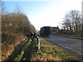
6
Farmyard at Whitechapel Farm
Just above the A69.
Image: © Oliver Dixon
Taken: 19 Dec 2007
0.08 miles
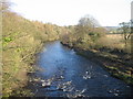
8
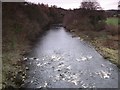
The River South Tyne downstream from Ridley Bridge
Image: © Mike Quinn
Taken: 26 Nov 2007
0.13 miles
9
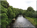
The River South Tyne
Looking downstream from Ridley Bridge.
Image: © David Purchase
Taken: 27 Aug 2015
0.15 miles