IMAGES TAKEN NEAR TO
Bardon Mill, HEXHAM, NE47 7AS
Introduction
This page details the photographs taken nearby to NE47 7AS by members of the Geograph project.
The Geograph project started in 2005 with the aim of publishing, organising and preserving representative images for every square kilometre of Great Britain, Ireland and the Isle of Man.

There are currently over 7.5m images from over14,400 individuals and you can help contribute to the project by visiting https://www.geograph.org.uk
Image Map
Images are licensed for reuse under creativecommons.org/licenses/by-sa/2.0
Notes
- Clicking on the map will re-center to the selected point.
- The higher the marker number, the further away the image location is from the centre of the postcode.
Image Listing (34 Images Found)
Images are licensed for reuse under creativecommons.org/licenses/by-sa/2.0
Image
Details
Distance

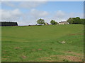
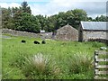
4
Greenlee Farm
One of many remote farms scattered throughout the vast area north of Hadrian's Wall. It is owned by the National Trust.
Image: © Karl and Ali
Taken: 23 Jun 2016
0.01 miles
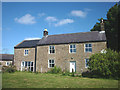
5
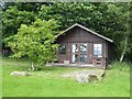
Summer house at Greenlee Farm
A very substantial summerhouse in the garden of Greenlee Farm, backed by Wark Forest.
Image: © Oliver Dixon
Taken: 23 Jun 2020
0.01 miles

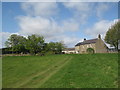
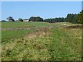
7
Track, moorland and plantation near Greenlee
Image: © Mike Quinn
Taken: 7 May 2009
0.01 miles
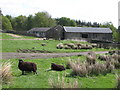
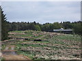
8
Outbuildings at Greenlee Farm
Backed by Wark Forest.
Image: © Oliver Dixon
Taken: 23 Jun 2020
0.02 miles
9
Greenlee
Greenlee is a deer stalking centre on the edge of Wark Forest.
Image: © Oliver Dixon
Taken: 12 Oct 2010
0.02 miles