IMAGES TAKEN NEAR TO
Bardon Mill, HEXHAM, NE47 7AE
Introduction
This page details the photographs taken nearby to NE47 7AE by members of the Geograph project.
The Geograph project started in 2005 with the aim of publishing, organising and preserving representative images for every square kilometre of Great Britain, Ireland and the Isle of Man.

There are currently over 7.5m images from over14,400 individuals and you can help contribute to the project by visiting https://www.geograph.org.uk
Image Map
Images are licensed for reuse under creativecommons.org/licenses/by-sa/2.0
Notes
- Clicking on the map will re-center to the selected point.
- The higher the marker number, the further away the image location is from the centre of the postcode.
Image Listing (17 Images Found)
Images are licensed for reuse under creativecommons.org/licenses/by-sa/2.0
Image
Details
Distance
1
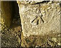
Ordnance Survey Cut Mark
This OS cut mark can be found on West Morwood. It marks a point 235.973m above mean sea level.
Image: © Adrian Dust
Taken: 7 Feb 2020
0.01 miles
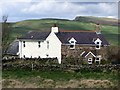
3
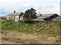
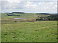
West Morwood
A lonely farm on the Stanegate, a Roman road which ran from Carlisle to Corbridge. Grindon Lough Image can be just seen beyond.
Image: © Oliver Dixon
Taken: 14 Apr 2008
0.03 miles
6
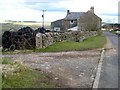
Farmland west of Morwood
Image: © Mike Quinn
Taken: 25 Aug 2010
0.15 miles
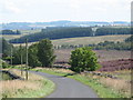
9
Farmland north of Morwood
Photo taken from The Stanegate in Image
Image: © Mike Quinn
Taken: 25 Aug 2010
0.16 miles
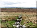
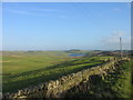
10
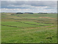
East Moorwood on Stanegate
View towards Hadrian's Wall at Sewingshields Crags.
Image: © Andrew Curtis
Taken: 11 Apr 2014
0.16 miles