IMAGES TAKEN NEAR TO
North Bank, HEXHAM, NE47 6LZ
Introduction
This page details the photographs taken nearby to North Bank, NE47 6LZ by members of the Geograph project.
The Geograph project started in 2005 with the aim of publishing, organising and preserving representative images for every square kilometre of Great Britain, Ireland and the Isle of Man.

There are currently over 7.5m images from over14,400 individuals and you can help contribute to the project by visiting https://www.geograph.org.uk
Image Map
Images are licensed for reuse under creativecommons.org/licenses/by-sa/2.0
Notes
- Clicking on the map will re-center to the selected point.
- The higher the marker number, the further away the image location is from the centre of the postcode.
Image Listing (17 Images Found)
Images are licensed for reuse under creativecommons.org/licenses/by-sa/2.0
Image
Details
Distance
1
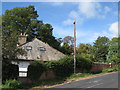
The top of North Bank
Shows the location of Image
Image: © Mike Quinn
Taken: 16 Sep 2010
0.02 miles
2
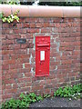
Victorian postbox in Haydon Bridge
These lovely Victorian postboxes always remind me of Penny Blacks and of the good old bad old days when BT, the Post Office and the Royal Mail were all one integrated organisation and telephones had dials and every little village had a Post Office where you could buy your wireless licence and there were (at least) two postal deliveries every day except Sundays. Hmmmm, nostalgia ain't what it used to be. The location of this postbox is shown in Image
Image: © Mike Quinn
Taken: 20 Jun 2007
0.03 miles
3

Tofts Bank, near Haydon Bridge (2)
Shows the location of Image
Image: © Mike Quinn
Taken: 19 Aug 2010
0.04 miles
4
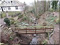
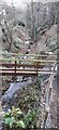
Footbridge across an Unnamed Stream
Impressive water feature in a beautiful garden.
Image: © Les Hull
Taken: 13 Mar 2018
0.04 miles
5
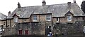
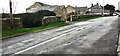
Highfield and Burnbrae on south side of North Bank
There is an Ordnance Survey benchmark Image on the left hand side of the left hand house at its front corner
Image: © Roger Templeman
Taken: 26 Feb 2022
0.06 miles
6
Stream flowing north from Tofts Bank
The stream banks are covered with snowdrops
Image: © Luke Shaw
Taken: 26 Feb 2022
0.06 miles
7
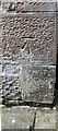
Benchmark on east face of Highfield
Ordnance Survey cut mark benchmark levelled at 118.025m above Newlyn Datum verified 1954
Image: © Roger Templeman
Taken: 26 Feb 2022
0.06 miles
8
North Bank at entrances to Rowan Rigg and Maresfield
There is an Ordnance Survey benchmark Image on the road face of the gatepost at the right hand side of the near entrance
Image: © Roger Templeman
Taken: 26 Feb 2022
0.10 miles
9
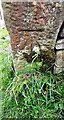
Benchmark on gatepost in wall on south side of North Bank opposite Bank House
Ordnance Survey cut mark benchmark levelled in 1954 at 111.462m above Newlyn Datum
Image: © Roger Templeman
Taken: 26 Feb 2022
0.11 miles
10

Cast iron water hydrant, Tofts Bank
This hydrant is similar to those in Allendale, eg Image, but without the lion's head. The location of this hydrant is shown in Image and Image
Image: © Mike Quinn
Taken: 19 Aug 2010
0.15 miles