IMAGES TAKEN NEAR TO
North Bank, HEXHAM, NE47 6LX
Introduction
This page details the photographs taken nearby to North Bank, NE47 6LX by members of the Geograph project.
The Geograph project started in 2005 with the aim of publishing, organising and preserving representative images for every square kilometre of Great Britain, Ireland and the Isle of Man.

There are currently over 7.5m images from over14,400 individuals and you can help contribute to the project by visiting https://www.geograph.org.uk
Image Map
Images are licensed for reuse under creativecommons.org/licenses/by-sa/2.0
Notes
- Clicking on the map will re-center to the selected point.
- The higher the marker number, the further away the image location is from the centre of the postcode.
Image Listing (73 Images Found)
Images are licensed for reuse under creativecommons.org/licenses/by-sa/2.0
Image
Details
Distance
1
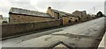
Haydon Park House, south side North Bank
There is an Ordnance Survey benchmark Image on the house jut at the right hand side of the metal entrance gate
Image: © Roger Templeman
Taken: 26 Feb 2022
0.02 miles
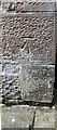
2
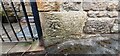
Benchmark on roadside jut of Haydon Park House on south side of North Bank
Ordnance Survey cut mark benchmark levelled at 96.168m above Newlyn Datum in 1954
Image: © Roger Templeman
Taken: 26 Feb 2022
0.02 miles
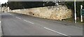
3
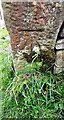
Benchmark on gatepost in wall on south side of North Bank opposite Bank House
Ordnance Survey cut mark benchmark levelled in 1954 at 111.462m above Newlyn Datum
Image: © Roger Templeman
Taken: 26 Feb 2022
0.08 miles
4
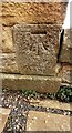
Benchmark on the west side of 3 South View, North Bank
Ordnance Survey cut mark benchmark levelled at 82.598m above Newlyn Datum verified 1954
Image: © Roger Templeman
Taken: 26 Feb 2022
0.09 miles
5
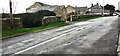
North Bank at entrances to Rowan Rigg and Maresfield
There is an Ordnance Survey benchmark Image on the road face of the gatepost at the right hand side of the near entrance
Image: © Roger Templeman
Taken: 26 Feb 2022
0.09 miles
6
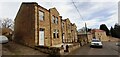
Houses of South View on north side of North Bank
There is an Ordnance Survey benchmark Image on the front corner, left hand face, of the nearest house
Image: © Roger Templeman
Taken: 26 Feb 2022
0.10 miles
7
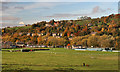
Haydon Bridge
View of Haydon Bridge on the River South Tyne.
Image: © Peter McDermott
Taken: 30 Oct 2010
0.12 miles
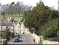
9
Looking NW along North Bank as it passes Haydon Lodge
There is an Ordnance Survey benchmark Image on the stone wall about 2m right of its corner near the right hand edge of the image
Image: © Roger Templeman
Taken: 26 Feb 2022
0.13 miles
10
Benchmark on east face of Highfield
Ordnance Survey cut mark benchmark levelled at 118.025m above Newlyn Datum verified 1954
Image: © Roger Templeman
Taken: 26 Feb 2022
0.14 miles