IMAGES TAKEN NEAR TO
Haydon Bridge, HEXHAM, NE47 6LL
Introduction
This page details the photographs taken nearby to NE47 6LL by members of the Geograph project.
The Geograph project started in 2005 with the aim of publishing, organising and preserving representative images for every square kilometre of Great Britain, Ireland and the Isle of Man.

There are currently over 7.5m images from over14,400 individuals and you can help contribute to the project by visiting https://www.geograph.org.uk
Image Map
Images are licensed for reuse under creativecommons.org/licenses/by-sa/2.0
Notes
- Clicking on the map will re-center to the selected point.
- The higher the marker number, the further away the image location is from the centre of the postcode.
Image Listing (220 Images Found)
Images are licensed for reuse under creativecommons.org/licenses/by-sa/2.0
Image
Details
Distance
1
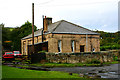
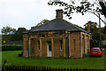
Former N&CR station house, Haydon Bridge - south-west elevation
Haydon Bridge was the terminus between June 1836 - June 1838, of the eastern section of the Newcastle & Carlisle Railway from Newcastle. The N&CR which was built in stages, opened throughout on 18th June 1838 and was not amalgamated with the North Eastern Railway until July 1862. An earlier image can be seen at Image The building is now a private house.
Image: © David Kemp
Taken: 27 Sep 2019
0.03 miles
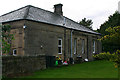
2
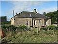
Station Cottages, Haydon Bridge
Former ticket office and stationmaster's house at Haydon Bridge Railway Station, c.1835, now a private house.
The frontage to the railway is shown here Image and one from 1956 here Image
Station Cottages is a Grade II Listed Building (List Entry: 1042506)
"An important and well preserved example of an early railway building of some architectural pretension."
https://historicengland.org.uk/listing/the-list/list-entry/1042506
The Newcastle and Carlisle Railway was formed in 1829, and was opened in stages. The station at Haydon Bridge originally opened as a terminus, presumably using this building, following completion of the line between Hexham and Haydon Bridge in June 1836. The line was eventually extended west to Greenhead in 1838, and the station moved north-west to its current location on the west-east lines Image The building shown here became central to a large goods yard located to the south of the main lines. The west part of the yard is now occupied by a distribution centre for a major store chain, and some industrial units.
Before the railway came to the Tyne valley lead ore would have been conveyed to local smelt mills by packhorse and horse and carts, as the distances and terrain were unsuitable for horse-drawn waggonways used in the coal fields of the north-east. Output of lead from the smelt mills also needed to be carried by road, for further refinement and further use in specialised mills in Newcastle and Gateshead.
Building of the Newcastle to Carlisle Railway allowed onward transport by train. Before the building of the Hexham & Allendale Railway in 1867, Haydon Bridge Railway Station was a major link from the Allendale and Allenheads area to the outside world. Lead that was mined and smelted at the Smelt Mills of Allenheads, Langley, or Allen Mill near Allendale Town was conveyed along cart tracks to the station. Building of the Hexham & Allendale Railway in 1867 gave the lead trade in this area a more direct rail transport route. However, this trade proved only short-lived. By 1870 the lead industry was declining; jobs in mines and smelters were lost, and the population severely reduced. The smelters at Langley and Allendale had closed by the mid-1880s, and only one important lead mine (near Allenheads) survived until World War I. The Hexham & Allendale Railway was bought out by the North Eastern Railway on 13 July 1876. The line was never extended as far as Allendale Town and the further 7 miles to Allenheads was not attempted. The branch line was closed to passengers in 1930 and to goods in 1950.
Disused Stations: http://www.disused-stations.org.uk/l/langley/index.shtml
Image: © Andrew Curtis
Taken: 15 Sep 2022
0.03 miles
3
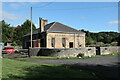
Station Cottages, Haydon Bridge
See description here Image
Image: © Andrew Curtis
Taken: 15 Sep 2022
0.03 miles
4
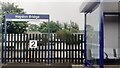
Haydon Bridge Station carpark viewed through station platform fence
This side for trains to Carlisle.
Image: © Luke Shaw
Taken: 21 Aug 2021
0.03 miles
5
Former N&CR station house, Haydon Bridge - north elevation
Haydon Bridge was the terminus between June 1836 - June 1838, of the eastern section of the Newcastle & Carlisle Railway from Newcastle. The N&CR which was built in stages, opened throughout on 18th June 1838 and was not amalgamated with the North Eastern Railway until July 1862. Seen here is the part of the building that abutted the track. The picture was taken from the platform of the present station. An earlier image can be seen at Image
Image: © David Kemp
Taken: 27 Sep 2019
0.03 miles
6
Former N&CR station house, Haydon Bridge - east elevation
Haydon Bridge was the terminus between June 1836 - June 1838, of the eastern section of the Newcastle & Carlisle Railway from Newcastle. The N&CR which was built in stages, opened throughout on 18th June 1838 and was not amalgamated with the North Eastern Railway until July 1862. The building is now a private house. An earlier image can be seen at Image
Image: © David Kemp
Taken: 27 Sep 2019
0.03 miles
7

A tree in a grave in St. Cuthbert's Church, Graveyard
Image: © PAUL FARMER
Taken: 24 Sep 2009
0.04 miles
10
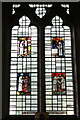
Stained glass, St Cuthbert's Church, Haydon Bridge
Four panels of stained glass by Leonard Evetts (1909-1997) based on an illustrated manuscript written in Durham c.1200 of Bede's Life of Saint Cuthbert.
Image: © Andrew Curtis
Taken: 15 Sep 2022
0.05 miles