IMAGES TAKEN NEAR TO
Haydon Bridge, HEXHAM, NE47 6ED
Introduction
This page details the photographs taken nearby to NE47 6ED by members of the Geograph project.
The Geograph project started in 2005 with the aim of publishing, organising and preserving representative images for every square kilometre of Great Britain, Ireland and the Isle of Man.

There are currently over 7.5m images from over14,400 individuals and you can help contribute to the project by visiting https://www.geograph.org.uk
Image Map
Images are licensed for reuse under creativecommons.org/licenses/by-sa/2.0
Notes
- Clicking on the map will re-center to the selected point.
- The higher the marker number, the further away the image location is from the centre of the postcode.
Image Listing (6 Images Found)
Images are licensed for reuse under creativecommons.org/licenses/by-sa/2.0
Image
Details
Distance
2
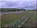
New road layout at turnoff from A69 to Haydon Bridge
Image: © Darrin Antrobus
Taken: 16 May 2009
0.10 miles
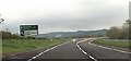
5
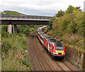
VTEC diversions - 16 September 2017 (7)
Virgin Trains East Coast HST 43277 dives under the A69 on the approach to Haydon Bridge with the diverted 07.55 passenger service from Inverness to King's Cross.
Image: © The Carlisle Kid
Taken: 16 Sep 2017
0.24 miles
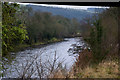
6
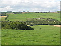
The valley of the River South Tyne north of West Land Ends
Image: © Mike Quinn
Taken: 19 Aug 2010
0.25 miles