IMAGES TAKEN NEAR TO
Haydon Bridge, HEXHAM, NE47 6DX
Introduction
This page details the photographs taken nearby to NE47 6DX by members of the Geograph project.
The Geograph project started in 2005 with the aim of publishing, organising and preserving representative images for every square kilometre of Great Britain, Ireland and the Isle of Man.

There are currently over 7.5m images from over14,400 individuals and you can help contribute to the project by visiting https://www.geograph.org.uk
Image Map
Images are licensed for reuse under creativecommons.org/licenses/by-sa/2.0
Notes
- Clicking on the map will re-center to the selected point.
- The higher the marker number, the further away the image location is from the centre of the postcode.
Image Listing (11 Images Found)
Images are licensed for reuse under creativecommons.org/licenses/by-sa/2.0
Image
Details
Distance
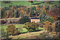
1
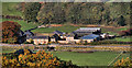
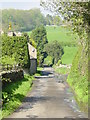
Lipwood Well
View of Lipwood Well Farm seen from above Lees Farm.
Image: © Peter McDermott
Taken: 30 Oct 2010
0.04 miles
2
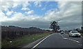
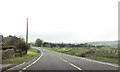
A69 near Lipwood
Always a bit disconcerting when you meet a train on this part of the road.
Image: © wfmillar
Taken: 9 Mar 2014
0.08 miles
3

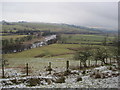
The valley of the River South Tyne below Lees Heugh
Image: © Mike Quinn
Taken: 19 Aug 2010
0.13 miles
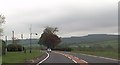
7
A69 approaching entrance to Willow Gap
Entrance to Willow Gap is via a level crossing across the railway
Image: © John Firth
Taken: 19 May 2013
0.20 miles
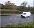
8
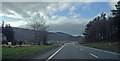
A69 near Lipwood
The Carlisle/Newcastle railway on the left of the road.
Image: © wfmillar
Taken: 9 Mar 2014
0.21 miles
10
Willow Gap
The cottages at Willow Gap alongside the River South Tyne.
Image: © Peter McDermott
Taken: 30 Oct 2010
0.24 miles