IMAGES TAKEN NEAR TO
Langley-on-Tyne, HEXHAM, NE47 5NU
Introduction
This page details the photographs taken nearby to NE47 5NU by members of the Geograph project.
The Geograph project started in 2005 with the aim of publishing, organising and preserving representative images for every square kilometre of Great Britain, Ireland and the Isle of Man.

There are currently over 7.5m images from over14,400 individuals and you can help contribute to the project by visiting https://www.geograph.org.uk
Image Map
Images are licensed for reuse under creativecommons.org/licenses/by-sa/2.0
Notes
- Clicking on the map will re-center to the selected point.
- The higher the marker number, the further away the image location is from the centre of the postcode.
Image Listing (10 Images Found)
Images are licensed for reuse under creativecommons.org/licenses/by-sa/2.0
Image
Details
Distance
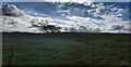
3
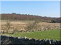
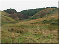
Langley Moss
Rather marshy ground near Carts Bog.
Image: © Oliver Dixon
Taken: 27 Mar 2012
0.12 miles
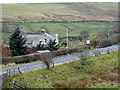
4
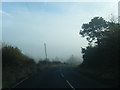
A686 nears lane junction, west of Langley
Image: © Colin Pyle
Taken: 3 Nov 2015
0.12 miles
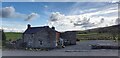
6
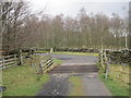
Cattle Grid and end of Drive from Harsondale
Image: © Les Hull
Taken: 30 Mar 2011
0.20 miles