IMAGES TAKEN NEAR TO
Langley-on-Tyne, HEXHAM, NE47 5LY
Introduction
This page details the photographs taken nearby to NE47 5LY by members of the Geograph project.
The Geograph project started in 2005 with the aim of publishing, organising and preserving representative images for every square kilometre of Great Britain, Ireland and the Isle of Man.

There are currently over 7.5m images from over14,400 individuals and you can help contribute to the project by visiting https://www.geograph.org.uk
Image Map
Images are licensed for reuse under creativecommons.org/licenses/by-sa/2.0
Notes
- Clicking on the map will re-center to the selected point.
- The higher the marker number, the further away the image location is from the centre of the postcode.
Image Listing (10 Images Found)
Images are licensed for reuse under creativecommons.org/licenses/by-sa/2.0
Image
Details
Distance
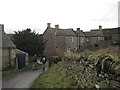
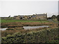
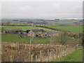
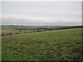
4
West Deanraw
Looking across the duck pond on Deanraw Burn to West Deanraw Farm.
Image: © Peter McDermott
Taken: 30 Oct 2010
0.01 miles
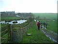
7
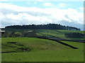
West Deanraw
I think we had a better day than the people who took the first Geograph!
Image: © 27th Newcastle Scouts
Taken: 9 Apr 2007
0.05 miles
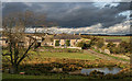
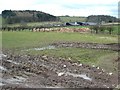
10
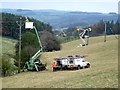
Installing a new electricity transmission line.
Near West Deanraw Farm. Subtitled "Dance of the cherry pickers".
Image: © Oliver Dixon
Taken: 18 Nov 2011
0.23 miles