IMAGES TAKEN NEAR TO
Langley-on-Tyne, HEXHAM, NE47 5LX
Introduction
This page details the photographs taken nearby to NE47 5LX by members of the Geograph project.
The Geograph project started in 2005 with the aim of publishing, organising and preserving representative images for every square kilometre of Great Britain, Ireland and the Isle of Man.

There are currently over 7.5m images from over14,400 individuals and you can help contribute to the project by visiting https://www.geograph.org.uk
Image Map
Images are licensed for reuse under creativecommons.org/licenses/by-sa/2.0
Notes
- Clicking on the map will re-center to the selected point.
- The higher the marker number, the further away the image location is from the centre of the postcode.
Image Listing (32 Images Found)
Images are licensed for reuse under creativecommons.org/licenses/by-sa/2.0
Image
Details
Distance
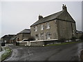
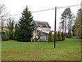
1
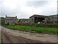
Castle Farm, Langley
The name refers to the nearby Langley Castle. Originally this farm was part of the Greenwich Hospital estates, providing income for the maintenance of the Hospital and its inmates.
Image: © Oliver Dixon
Taken: 10 Oct 2010
0.02 miles
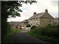
3

Castle Farm
The castle in question is Langley Castle nearby.
Image: © Oliver Dixon
Taken: 19 Apr 2021
0.05 miles
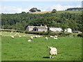
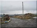
8
Pastures and woodland west of Castle Farm (3)
Image: © Mike Quinn
Taken: 11 Aug 2010
0.16 miles
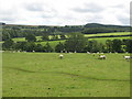
9
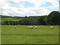
Pastures and woodland west of Castle Farm (2)
Image: © Mike Quinn
Taken: 11 Aug 2010
0.18 miles
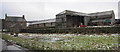
10
Castle View Lodge, Langley Castle
Rooms used as part of the Langley Castle Hotel.
Image: © Andrew Curtis
Taken: 5 Nov 2010
0.19 miles