IMAGES TAKEN NEAR TO
Newbrough, HEXHAM, NE47 5BG
Introduction
This page details the photographs taken nearby to NE47 5BG by members of the Geograph project.
The Geograph project started in 2005 with the aim of publishing, organising and preserving representative images for every square kilometre of Great Britain, Ireland and the Isle of Man.

There are currently over 7.5m images from over14,400 individuals and you can help contribute to the project by visiting https://www.geograph.org.uk
Image Map
Images are licensed for reuse under creativecommons.org/licenses/by-sa/2.0
Notes
- Clicking on the map will re-center to the selected point.
- The higher the marker number, the further away the image location is from the centre of the postcode.
Image Listing (15 Images Found)
Images are licensed for reuse under creativecommons.org/licenses/by-sa/2.0
Image
Details
Distance
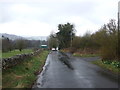
1
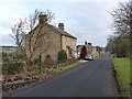
Row of cottages beside the Stanegate
Stanegate is the old Roman road from Carlisle to Corbridge, which here is now followed by Hadrian's Cycleway (National Cycle Network route 72).
Image: © Oliver Dixon
Taken: 24 Jan 2011
0.02 miles
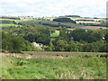
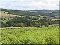
7
Burn at Stonecroft, near Newbrough
I am not sure of the name of this burn but I think it may be called Settlingstones Burn
Image: © Brian Norman
Taken: 17 Feb 2008
0.20 miles
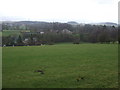
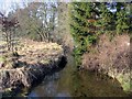
9
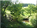
Footbridge and ford on Settlingstones Burn at Stonecroft
Image: © Mike Quinn
Taken: 4 Oct 2010
0.22 miles
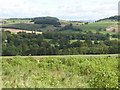
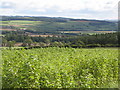
10
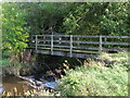
Footbridge over Settlingstones Burn at Stonecroft
Image: © Mike Quinn
Taken: 4 Oct 2010
0.23 miles