IMAGES TAKEN NEAR TO
Steel, HEXHAM, NE47 0LG
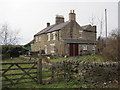
Introduction
This page details the photographs taken nearby to NE47 0LG by members of the Geograph project.
The Geograph project started in 2005 with the aim of publishing, organising and preserving representative images for every square kilometre of Great Britain, Ireland and the Isle of Man.

There are currently over 7.5m images from over14,400 individuals and you can help contribute to the project by visiting https://www.geograph.org.uk
Image Map
Images are licensed for reuse under creativecommons.org/licenses/by-sa/2.0
Notes
- Clicking on the map will re-center to the selected point.
- The higher the marker number, the further away the image location is from the centre of the postcode.
Image Listing (38 Images Found)
Images are licensed for reuse under creativecommons.org/licenses/by-sa/2.0
Image
Details
Distance
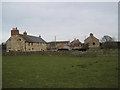
1
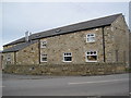
Dairy House, Steel
Can only assume that this was once a dairy.
Image: © Les Hull
Taken: 3 Mar 2010
0.01 miles
2
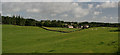
Steel
Fields above the hamlet of Steel.
Image: © Peter McDermott
Taken: 29 Aug 2009
0.02 miles
6
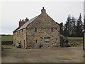
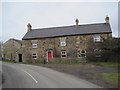
Former Farm Buildings at Steel
A range of farm buildings at Steel probably date back to the 16th century and may have been a defensive house a bit like a bastle. There are three phases of development in the building from the 16th through to the 18th centuries. Some features of the buildings are similar to those found in bastles. For example some of the walls are about one metre thick, small openings in the walls called slit vents. This is a Grade II Listed Building protected by law.
http://www.keystothepast.info/durhamcc/K2P.nsf/K2PDetail?readform&PRN=N8340
When we first walked past this building about ten years ago it was almost derelict.
Image: © Les Hull
Taken: 3 Mar 2010
0.04 miles
9
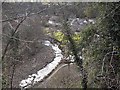
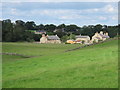
Black Hall Mill
A cluster of five houses in the valley of the Rowley Burn at the bottom of a steep bank below Juniper village.
Image: © Oliver Dixon
Taken: 6 Mar 2009
0.10 miles
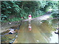
10
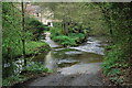
Juniper Ford
This ford is found at Blackhall Mill. The ford has a dog-leg which at high water levels can catch drivers out.
http://youtu.be/R2c8-N1V-BA
https://youtu.be/BnOJkpIWps8
Image: © John Walton
Taken: 3 May 2014
0.11 miles