IMAGES TAKEN NEAR TO
Stobby Lea, HEXHAM, NE47 0JF
Introduction
This page details the photographs taken nearby to Stobby Lea, NE47 0JF by members of the Geograph project.
The Geograph project started in 2005 with the aim of publishing, organising and preserving representative images for every square kilometre of Great Britain, Ireland and the Isle of Man.

There are currently over 7.5m images from over14,400 individuals and you can help contribute to the project by visiting https://www.geograph.org.uk
Image Map
Images are licensed for reuse under creativecommons.org/licenses/by-sa/2.0
Notes
- Clicking on the map will re-center to the selected point.
- The higher the marker number, the further away the image location is from the centre of the postcode.
Image Listing (11 Images Found)
Images are licensed for reuse under creativecommons.org/licenses/by-sa/2.0
Image
Details
Distance
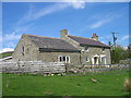
1
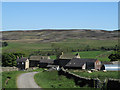
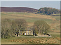
Stobby Lea Farm
The farm is seen from its access road; beyond, over the valley of Devil's Water, rises the heather moorland of Round Hill.
Image: © Trevor Littlewood
Taken: 30 May 2009
0.02 miles
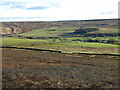
3
The valley of Devil's Water east of Stobby Lea
Image: © Mike Quinn
Taken: 27 Jan 2023
0.18 miles
6
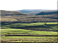
The valley of Devil's Water between Harwood Shield and Stobby Lea
Image: © Mike Quinn
Taken: 27 Jan 2023
0.19 miles
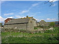
7
Steel
Possibly once a small farm but has been renovated but not necessarily in the best possible taste. footpath goes through its grounds and there are stables at the back.
Image: © Les Hull
Taken: 11 May 2006
0.20 miles
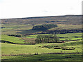
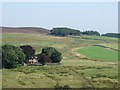
8
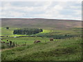
Rough pastures around Stobby Lea
Looking past the square plantation west of Low Hope towards Image
Image: © Mike Quinn
Taken: 9 Aug 2011
0.23 miles
9
Rough pastures around Harwood Shield
Photo taken from the track to the south of the farm in Image
Image: © Mike Quinn
Taken: 19 Mar 2022
0.24 miles