IMAGES TAKEN NEAR TO
Steel, HEXHAM, NE47 0JB
Introduction
This page details the photographs taken nearby to NE47 0JB by members of the Geograph project.
The Geograph project started in 2005 with the aim of publishing, organising and preserving representative images for every square kilometre of Great Britain, Ireland and the Isle of Man.

There are currently over 7.5m images from over14,400 individuals and you can help contribute to the project by visiting https://www.geograph.org.uk
Image Map
Images are licensed for reuse under creativecommons.org/licenses/by-sa/2.0
Notes
- Clicking on the map will re-center to the selected point.
- The higher the marker number, the further away the image location is from the centre of the postcode.
Image Listing (12 Images Found)
Images are licensed for reuse under creativecommons.org/licenses/by-sa/2.0
Image
Details
Distance
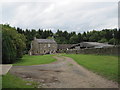
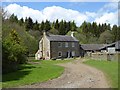
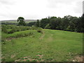
4
Burntshields Haugh
Probably a converted farmhouse.
Image: © Les Hull
Taken: 10 Jul 2018
0.02 miles
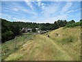
5
Burntshield Haugh Farm
In the valley of the Devil's Water.
Image: © Oliver Dixon
Taken: 20 May 2016
0.04 miles
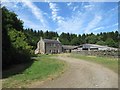
6
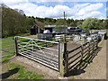
Animal pen, Burntshield Haugh Farm
In the valley of the Devil's Water.
Image: © Oliver Dixon
Taken: 20 May 2016
0.05 miles
7
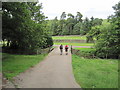
Footpath over Road Bridge near Burntshield Haugh
Image: © Les Hull
Taken: 19 Jul 2010
0.06 miles
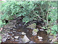
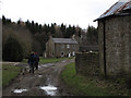
10
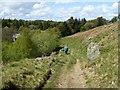
Footpath down to Burntshield Haugh Farm
In the well-wooded valley of the Devil's Water.
Image: © Oliver Dixon
Taken: 20 May 2016
0.12 miles