IMAGES TAKEN NEAR TO
Steel, HEXHAM, NE47 0HU
Introduction
This page details the photographs taken nearby to NE47 0HU by members of the Geograph project.
The Geograph project started in 2005 with the aim of publishing, organising and preserving representative images for every square kilometre of Great Britain, Ireland and the Isle of Man.

There are currently over 7.5m images from over14,400 individuals and you can help contribute to the project by visiting https://www.geograph.org.uk
Image Map
Images are licensed for reuse under creativecommons.org/licenses/by-sa/2.0
Notes
- Clicking on the map will re-center to the selected point.
- The higher the marker number, the further away the image location is from the centre of the postcode.
Image Listing (4 Images Found)
Images are licensed for reuse under creativecommons.org/licenses/by-sa/2.0
Image
Details
Distance
1
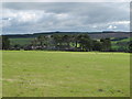
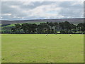
Pastures and woodland west of White Hall (2)
Image: © Mike Quinn
Taken: 9 Aug 2011
0.13 miles
2
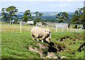
Sheep between fence and streamlet
Surely the most cute sheep around, these are beside a stream flowing down towards the unusually named farm, Litharge. The fence behind them is an electric one, installed temporarily.
(Note: Litharge is a lead compound - a lead oxide, formula PbO.)
Image: © Trevor Littlewood
Taken: 18 Jul 2019
0.14 miles
3
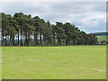
Pastures and woodland west of White Hall (3)
Image: © Mike Quinn
Taken: 9 Aug 2011
0.15 miles