IMAGES TAKEN NEAR TO
Steel, HEXHAM, NE47 0HS
Introduction
This page details the photographs taken nearby to NE47 0HS by members of the Geograph project.
The Geograph project started in 2005 with the aim of publishing, organising and preserving representative images for every square kilometre of Great Britain, Ireland and the Isle of Man.

There are currently over 7.5m images from over14,400 individuals and you can help contribute to the project by visiting https://www.geograph.org.uk
Image Map
Images are licensed for reuse under creativecommons.org/licenses/by-sa/2.0
Notes
- Clicking on the map will re-center to the selected point.
- The higher the marker number, the further away the image location is from the centre of the postcode.
Image Listing (31 Images Found)
Images are licensed for reuse under creativecommons.org/licenses/by-sa/2.0
Image
Details
Distance
1
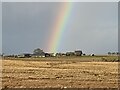
Dig here for a pot of gold!
The rainbow seemingly ends at Gair Shield Farm.
Image: © Oliver Dixon
Taken: 20 Dec 2022
0.01 miles
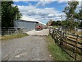
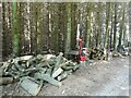
3
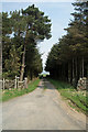
Farm road to Gair Shield Farm
Public footpath status.
Image: © Oliver Dixon
Taken: 26 Jul 2022
0.03 miles
6
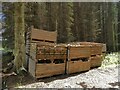
Forest operations in Kingslaw Plantation
Saw table and logs.
Image: © Oliver Dixon
Taken: 26 Jul 2022
0.15 miles
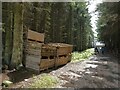
8
Forest operations in Kingslaw Plantation
Saw table and logs.
Image: © Oliver Dixon
Taken: 26 Jul 2022
0.17 miles
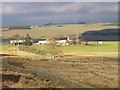
9
Gair Shield
Track leading to Gair Shield.
Image: © Peter McDermott
Taken: 10 May 2008
0.17 miles
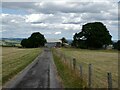
10
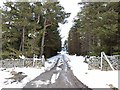
Farm road to Gair Shield
Farm road and public footpath leading through Kingslaw Plantation. Compare with Image
Image: © Oliver Dixon
Taken: 29 Mar 2013
0.18 miles