IMAGES TAKEN NEAR TO
Steel, HEXHAM, NE47 0HR
Introduction
This page details the photographs taken nearby to NE47 0HR by members of the Geograph project.
The Geograph project started in 2005 with the aim of publishing, organising and preserving representative images for every square kilometre of Great Britain, Ireland and the Isle of Man.

There are currently over 7.5m images from over14,400 individuals and you can help contribute to the project by visiting https://www.geograph.org.uk
Image Map
Images are licensed for reuse under creativecommons.org/licenses/by-sa/2.0
Notes
- Clicking on the map will re-center to the selected point.
- The higher the marker number, the further away the image location is from the centre of the postcode.
Image Listing (27 Images Found)
Images are licensed for reuse under creativecommons.org/licenses/by-sa/2.0
Image
Details
Distance
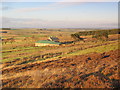
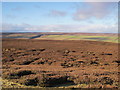
3
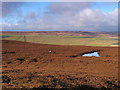
Cocker Shield below King's Law
Photo taken from near the crossroads of tracks on the eastern edge of Burntridge Moor in Image
Image: © Mike Quinn
Taken: 29 Jul 2007
0.01 miles
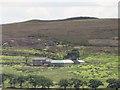
6

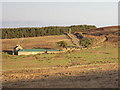
Cocker Shield Farm
A lonely farm on Hexhamshire Common. Lilswood Moor beyond.
Image: © Oliver Dixon
Taken: 8 Jul 2008
0.03 miles
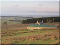
7
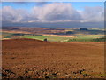
Panorama from King's Law (4: WNW - Moorland above Cocker Shield)
Image: © Mike Quinn
Taken: 18 Jan 2011
0.12 miles