IMAGES TAKEN NEAR TO
Steel, HEXHAM, NE47 0HE
Introduction
This page details the photographs taken nearby to NE47 0HE by members of the Geograph project.
The Geograph project started in 2005 with the aim of publishing, organising and preserving representative images for every square kilometre of Great Britain, Ireland and the Isle of Man.

There are currently over 7.5m images from over14,400 individuals and you can help contribute to the project by visiting https://www.geograph.org.uk
Image Map
Images are licensed for reuse under creativecommons.org/licenses/by-sa/2.0
Notes
- Clicking on the map will re-center to the selected point.
- The higher the marker number, the further away the image location is from the centre of the postcode.
Image Listing (23 Images Found)
Images are licensed for reuse under creativecommons.org/licenses/by-sa/2.0
Image
Details
Distance
1
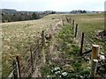
Double fence line near Holly Bush Close
The purpose of this double fence line is not clear. The trees to the left mark the course of the Rowley Burn.
Image: © Oliver Dixon
Taken: 6 Mar 2021
0.03 miles
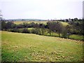
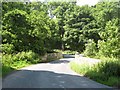
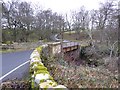
3

Dalton Bridge
Plantation and fields near Dalton Bridge.
Image: © Peter McDermott
Taken: 29 Aug 2009
0.13 miles
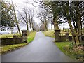
4
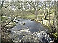
Rowley Burn
Looking downstream from Dalton Bridge.
Image: © Oliver Dixon
Taken: 30 Jan 2021
0.13 miles

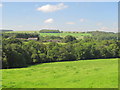
8
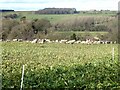
Sheep folded on root crop
Just outside Whitley Chapel. Dotland Image on the horizon.
Image: © Oliver Dixon
Taken: 30 Jan 2021
0.16 miles