IMAGES TAKEN NEAR TO
Slaley, HEXHAM, NE47 0DQ
Introduction
This page details the photographs taken nearby to NE47 0DQ by members of the Geograph project.
The Geograph project started in 2005 with the aim of publishing, organising and preserving representative images for every square kilometre of Great Britain, Ireland and the Isle of Man.

There are currently over 7.5m images from over14,400 individuals and you can help contribute to the project by visiting https://www.geograph.org.uk
Image Map
Images are licensed for reuse under creativecommons.org/licenses/by-sa/2.0
Notes
- Clicking on the map will re-center to the selected point.
- The higher the marker number, the further away the image location is from the centre of the postcode.
Image Listing (4 Images Found)
Images are licensed for reuse under creativecommons.org/licenses/by-sa/2.0
Image
Details
Distance
1
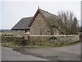
Marley Cote Walls Farm
Slaley Woods beyond.
Image: © Oliver Dixon
Taken: 26 Jan 2010
0.02 miles
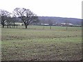
2
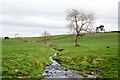
Black Burn
The Black Burn flowing eastwards from the farm at Slaley Vale.
Image: © Trevor Littlewood
Taken: 12 Mar 2017
0.06 miles
3
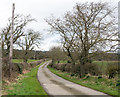
Ribbed concrete road near to Slaley Vale
Slaley Vale is a farm in the shallow valley of the minor stream, Black Burn. The road in the image gives access to it from the public route, North Road which lies in the direction of the view.
Image: © Trevor Littlewood
Taken: 12 Mar 2017
0.09 miles