IMAGES TAKEN NEAR TO
Slaley, HEXHAM, NE47 0DH
Introduction
This page details the photographs taken nearby to NE47 0DH by members of the Geograph project.
The Geograph project started in 2005 with the aim of publishing, organising and preserving representative images for every square kilometre of Great Britain, Ireland and the Isle of Man.

There are currently over 7.5m images from over14,400 individuals and you can help contribute to the project by visiting https://www.geograph.org.uk
Image Map
Images are licensed for reuse under creativecommons.org/licenses/by-sa/2.0
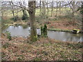
Notes
- Clicking on the map will re-center to the selected point.
- The higher the marker number, the further away the image location is from the centre of the postcode.
Image Listing (12 Images Found)
Images are licensed for reuse under creativecommons.org/licenses/by-sa/2.0
Image
Details
Distance
2
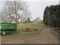
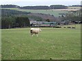
Todburn Steel Farm near Dipton Wood
Todburn Steel farmhouse includes a pair of 16th or 17th bastles. One is still used as a house. It seems probable that the western bastle was earlier, probably dating to the early 17th century. The eastern bastle is probably 20-30 years later in date. This is a Grade II Listed Building protected by law.
http://www.keystothepast.info/durhamcc/K2P.nsf/K2PDetail?readform&PRN=N8362
Image: © Les Hull
Taken: 17 Mar 2010
0.04 miles
3
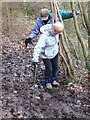
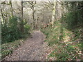
Muddy obstacle in Dipton Wood
The public footpath through the eastern end of Dipton Wood skirts above the deeply incised valley of Dipton Burn. At this point, the path is extremely muddy, and the stepping stones provided are difficult to negotiate.
Image: © Oliver Dixon
Taken: 2 Feb 2011
0.16 miles
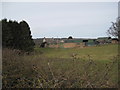
6
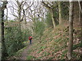
Todburn Steel Farm
The deeply incised valley of Dipton Burn and Dipton Wood lie beyond.
Image: © Oliver Dixon
Taken: 2 Feb 2011
0.18 miles
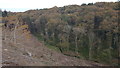
7
The valley of the Dipton Burn
Deeply incised valley on the southern edge of Dipton Wood.
Image: © Oliver Dixon
Taken: 2 Feb 2011
0.18 miles
8
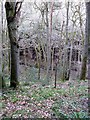
The banks of Dipton Burn
Some recent tree felling has exposed this view of Dipton Burn from the top of north bank, and allowing a view of the deciduous trees on the southern side of the stream.
Image: © Clive Nicholson
Taken: 30 Oct 2017
0.19 miles