IMAGES TAKEN NEAR TO
Fell Cottages, HEXHAM, NE47 0BU
Introduction
This page details the photographs taken nearby to Fell Cottages, NE47 0BU by members of the Geograph project.
The Geograph project started in 2005 with the aim of publishing, organising and preserving representative images for every square kilometre of Great Britain, Ireland and the Isle of Man.

There are currently over 7.5m images from over14,400 individuals and you can help contribute to the project by visiting https://www.geograph.org.uk
Image Map
Images are licensed for reuse under creativecommons.org/licenses/by-sa/2.0
Notes
- Clicking on the map will re-center to the selected point.
- The higher the marker number, the further away the image location is from the centre of the postcode.
Image Listing (11 Images Found)
Images are licensed for reuse under creativecommons.org/licenses/by-sa/2.0
Image
Details
Distance
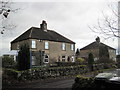
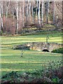
2
Fell Cottages
Adjoining the Coal Road through the grounds of Slaley Hall.
Image: © Oliver Dixon
Taken: 17 Jan 2009
0.02 miles
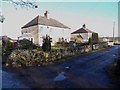
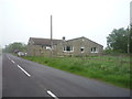
3
Farm near Slaley
Seen from the Coal Road.
Image: © Oliver Dixon
Taken: 17 Jan 2009
0.11 miles
4
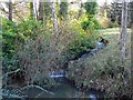
Small cascade in the grounds of Slaley Hall
A small artificial cascade on a tributary of the Boghall Burn.
Image: © Oliver Dixon
Taken: 17 Jan 2009
0.19 miles
5
Ring the bell!
Golfers on this course at Slaley Hall ring this bell when they leave the previous fairway.
Image: © Joan Sykes
Taken: 17 Jan 2009
0.20 miles
7
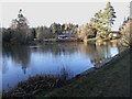
Lake in the grounds of Slaley Hall
Some of the private "lodges" can be seen on the far shore.
Image: © Oliver Dixon
Taken: 17 Jan 2009
0.21 miles
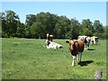
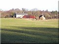
9
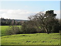
Pastures and woodland around Boghall Burn
Image: © Mike Quinn
Taken: 15 Dec 2011
0.23 miles
