IMAGES TAKEN NEAR TO
Slaley, HEXHAM, NE47 0BL
Introduction
This page details the photographs taken nearby to NE47 0BL by members of the Geograph project.
The Geograph project started in 2005 with the aim of publishing, organising and preserving representative images for every square kilometre of Great Britain, Ireland and the Isle of Man.

There are currently over 7.5m images from over14,400 individuals and you can help contribute to the project by visiting https://www.geograph.org.uk
Image Map
Images are licensed for reuse under creativecommons.org/licenses/by-sa/2.0
Notes
- Clicking on the map will re-center to the selected point.
- The higher the marker number, the further away the image location is from the centre of the postcode.
Image Listing (9 Images Found)
Images are licensed for reuse under creativecommons.org/licenses/by-sa/2.0
Image
Details
Distance
1
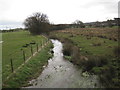
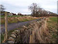
Flothers Farm
The narrow bridge in the foreground crosses Reaston Gill.
Image: © Oliver Dixon
Taken: 31 May 2020
0.05 miles
2
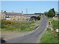
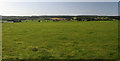
Flothers Farm
The farm buildings are to the right of the road, the farmhouse (which also runs as a bed and breakfast) to the left.
Image: © Oliver Dixon
Taken: 20 Dec 2011
0.06 miles
6
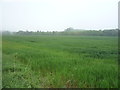
Slaley
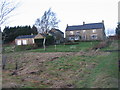
Fields at the east end of Slaley Village.
Image: © Peter McDermott
Taken: 29 Aug 2009
0.23 miles
8
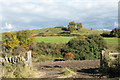
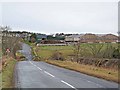
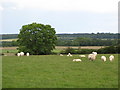
One of Reaston Hills
Reaston Hills form a minor feature close to the Northumbrian village of Slaley. The view is from a minor road across the valley of the Reaston Burn.
Image: © Trevor Littlewood
Taken: 14 Oct 2015
0.23 miles