IMAGES TAKEN NEAR TO
Slaley, HEXHAM, NE47 0AJ
Introduction
This page details the photographs taken nearby to NE47 0AJ by members of the Geograph project.
The Geograph project started in 2005 with the aim of publishing, organising and preserving representative images for every square kilometre of Great Britain, Ireland and the Isle of Man.

There are currently over 7.5m images from over14,400 individuals and you can help contribute to the project by visiting https://www.geograph.org.uk
Image Map
Images are licensed for reuse under creativecommons.org/licenses/by-sa/2.0
Notes
- Clicking on the map will re-center to the selected point.
- The higher the marker number, the further away the image location is from the centre of the postcode.
Image Listing (11 Images Found)
Images are licensed for reuse under creativecommons.org/licenses/by-sa/2.0
Image
Details
Distance
3
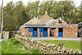
Stables at Blue Gables with cat on wall
Blue for the doors at the stabling as well as in the farm's name.
Image: © Trevor Littlewood
Taken: 6 May 2016
0.01 miles
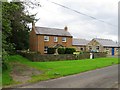
4
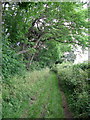
Lead Road
Looking west near Blue Gables Farm.
Image: © JThomas
Taken: 2 Apr 2016
0.02 miles
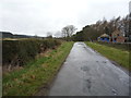
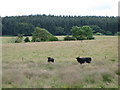
7
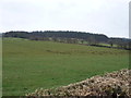
Grazing near Blue Gables Farm
Off Lead Road.
Image: © JThomas
Taken: 2 Apr 2016
0.05 miles
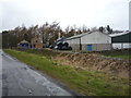
9
Farmland, plantations and the track to North Cocklake
Image: © Mike Quinn
Taken: 9 Jul 2007
0.13 miles
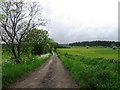
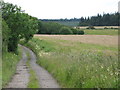
10
Pastures near Blue Gables
Part of Slaley Forest in the distance.
Image: © Mike Quinn
Taken: 9 Jul 2007
0.16 miles